|
|
|
|
|
|
| Home
Purpose Course Descriptions School Yachts Schedule of Courses Ocean Training Cruises ASA Certification Registration Info Our Location Our People Contact Us |
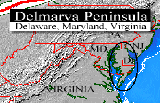
DELMARVA Circumnavigation Cruise
We were concerned that Hurricane FLOYD would force us to cancel this circumnavigation of the DELMARVA peninsula as Hurricane DENNIS had earlier this month . But, unlike his predecessor, FLOYD blew through our section of the Mid Atlantic States quickly and this class was able to meet and depart on schedule. And while we did not experience a hurricane on this trip, our crew had more than enough challenges to enhance their skills and build confidence. Joining us for this voyage were Bill Beatty of Germantown, MD, Linda Braterman and Pat Kearns both of Havre de Grace, MD, Doug Richie of Toronto, ONT., and Randall Washington of Marshallville, GA. Initial crew assignments had Pat as Navigator, Bill serving as Safety Coordinator, Randall assuming the Engineer duties, and Doug and Linda serving as Bosns. On Friday we conducted onboard checks and inspections, reviewed our preparation seminar topics, purchased food provisions, and made preliminary navigational plans. At 1900 we secured preparation work for the day and went out on the town of Rock Hall for some local, Eastern Shore cuisine. Saturday morning we rose early and continued our vessel inspections following the checklists in the Maryland Schools Offshore Manual, and by noon we were ready to depart. Light westerly winds required that we motor on our northward trip up the Bay toward the C&D Canal. But we had a stable platform and ideal conditions to work some navigational exercises including deviation checks of the ships compass using several of the navigational range lights in the North of Pooles Island. We arrived at the Canal shortly after 1900 and headed for the Shaffers fuel dock to top off fuel and water. This gave Engineer Randall a chance to analyze our fuel consumption which he computed to be 0.8 gph the 2500 rpm we were running on the trip up the Bay. Thus we had a benchmark to determine our range under power. At 1930 the ebbing current (290° in the canal) was strong, against us, and the anchorage at Engineers Cove across the canal from Shaffers, was crowded so we resolved to wait on the dock until favorable currents at about 0400 on Sunday. We relaxed and retired for the evening early to arise at 0300 for an 0400 departure. Sunday at 0435 we finally got underway again in patchy fog. Visibility varied from decent to pea soup and at 0520 a chagrined Doug, at the helm, put us aground in the soup, as he tried to follow the canal lights showing location of the banks. Checking the charts we found we were near a marsh just South of the canal channel and getting off was not a problem. By 0600 we were exiting the Canal as the dawn began to break and entered the top of Delaware Bay. Near the Salem Nuclear Plant at 0730 we were able to run the range lights of the Salem Range in the channel to determine our ships compass deviation.... 2° East on this heading. We would be able to use this on our DR plot going down the coast since we were on a heading close to our 190° to 200° magnetic course down the coast once we cleared Cape Henlopen. We continued down the bay keeping the green marks to port staying clear of shipping. During the afternoon we discussed emergency procedures and familiarized ourselves with the emergency gear as we made our way down the bay. Bill helped assign abandon ship duties for each crew member. Our timing of tidal currents proved to be right on the money so we made excellent progress on the ebbing tidal currents. The light winds made it necessary for us to motor most of this day too, but by 1400 the breeze freshened and we were able to proceed under sail. At 1545 we came to Cape Henlopen passing near two ferry boats, one bound for Cape Henlopen and the other for Cape May. By 1600 we were on the ocean, looking back to the breakwater light and the various towers on shore to get a fix with which to begin our ocean DR plot. We alternately sailed and motored throughout the night making good time, passing Ocean City at about 2300. We followed the Navy watch system of 4 hours. on, 8 off through the night and it worked well for everyone. This was the first night sail for most of the crew and all enjoyed the experience. Monday we conducted several exercises as we worked our way down the coast past Assateague Island and Great Machipango inlet. At 1200 we ended our DR plot exercise by getting a GPS position and plotting it on our DR plotting sheet. We found our true position was about 8 miles North of our DR plot, but right on the track, and Randall correctly attributed this to the number of Tacks he and Bill were forced to make during the Mid watch as the winds shifted to SSW. By 1430 the winds backed Eastward and we were able to make excellent time sailing past toward Nautilus shoals and on to Thimble Shoals channel at the southern entrance to Chesapeake Bay. As we headed for the bay the crew rotated billets. We appointed Pat as "Captain de Jour" responsible for making preparations for entering port. Doug assumed navigation responsibilities and Bill became Engineer with Linda becoming Boson. Doug found the harbor and Taylors Landing Marina and at 1700 Captain Pat ordered sails lowered and docklines made ready as we entered harbor and made our way past the USN Amphibious Base at Little Creak and headed for the dock with Linda at the helm. At 1730 we made fast to the fuel dock, secured the boat and headed for the showers. By 1845 we were ready to enjoy a sumptuous dinner ashore celebrating our successful ocean hop. On Tuesday, September 21 Captain de Jour Doug reviewed the situation with his Navigator, Linda, and determined that the approaching cold front would require us to get underway as early as possible and make as many miles North as we could, because the SW winds would clock to the North once the front passed through. So we fueled and topped off our water as soon as the Marina opened. By 0900, after a brief undocking seminar, we were underway and headed for Solomons Island. Crossing Thimble Shoals Channel provided an opportunity for Doug to determine the most efficient course for us to steer and at the same time avoid the heavy commercial and naval traffic in this busy channel. By 1500 we could see the approaching cirrus and altocumulus clouds building in the northwest, harbingers of the approaching cold front. And the winds were veering west to northwest. We had just passed Wolftrap at 1430 and it was becoming clear that we would not make it to Solomons before the front arrived, so Linda began researching an alternative safe harbor. She determined the Great Wicomico River looked like our best bet if the front came through with the expected north winds. So we planned a course for this new destination and prepared dinner so that we would have eaten a good hot meal prior to the cold front arrival. At 1830 the squalls started and the wind veered to north and freshened. We reefed the main and doused the genny. By 1930 we were experiencing steady 25+ knot winds with gusts over 35 knots and seas building to 4 to 5 feet as we inched our way north toward our Great Wicomico approach bearing under a double reefed main and staysail. With Bill and Randall on watch, and Doug and Linda plotting the course, we made our way to the Great Wicomico and a sheltered anchorage near Reedsville. At about 1900 I noticed odd slapping noise coming from the main, looked up and noted several seams near the leach had let go. We had to get it down fast before further damage occurred! Doug and Randall hooked on, went forward and wrestled the sail down, lashing it securely to the boom. We then motor sailed into the harbor with the staysail stabilizing the boat. By 2030 Doug and Linda were able to guide us to a sheltered anchorage. There we dropped the hook on a long rode and secured for the night. All were exhausted a glad to be in a safe harbor as the north winds howled through the rigging. We set an anchor watch and got some rest. Wednesday morning we arose at 0630, had a hearty oatmeal breakfast, cleaned up the boat and accessed the situation. Winds persisted out of the North and remained strong. Weather reports predicted these conditions would continue. I contacted the Maryland School through the loan of Dougs cell phone, and advise them of the sail situation. This done, we got under way and worked our way North past Smith Point Light under the staysail and the iron genoa! It was slow progress. At 1300 the school contacted us via VHF telephone hookup and we arranged that Tom Tursi would rendezvous with us at Solomons to pickup the sail for repairs at a sailmaker in Annapolis. But, at 1400 Pat, going below for boat checks after her watch, fell as the boat lurched in the 5 foot seas and bruised her hip. We hoped her injury wasnt serious, and Bill, a trained EMT, immobilized her and we contacted the Coast Guard and arranged for medical personnel to meet us at Point Lookout State Park, the closest port where we might get Pat safely off. By 1545 we were docked at the Point Lockout State Park Marina and emergency medical personnel from St. Marys Hospital in Leonardsville were aboard evaluating Pats condition. Fortunately things looked good, but they took her of to the hospital for examination just in case. Linda went with her and the rest of us planned to wait until morning before continuing on. Tom Tursi, in the meantime diverted to our location, picked up the sail, joined us for chili dinner and headed off to visit Pat in the hospital; he was very grateful that her examination checked out favorably and that she was about to be released to return home. The remaining crew reflected on the days events and lessons and came to a better realization of the inherent dangers in going to sea in little boats and the adage "One hand for the boat, one for yourself." Thursday morning, after breakfast, we made ready to get underway, and at 0615 we were away and heading up the bay again. Captain de Jour Randall and Navigator Bill guided us past Cedar Point and the Patuxent River, into the Choptank River, through Knapps Narrows, through the cut between Poplar Island and Tilgman Island and on into the Eastern Bay conducting many navigational exercises along the way. They made several comparisons between position fixes obtained by traditional coastal navigation techniques and simultaneous GPS fixes, and were surprised at the accuracy and ease of their manual techniques after a bit of practice. By 1600 we were at Kent Narrows and, passing through the draw bridge, we docked at the Mears fuel dock on the North side where we fueled, watered and pumped out. This provided yet another docking/undocking exercise which we took the time to analyze before moving on to a local restaurant for dinner ashore. Afterwards, we allowed enough time for the full dark of evening to settle in before embarking for Rock Hall on the final leg of this circumnavigation. Bill, Randall and Doug spent an hour preparing for the night exercises to follow. They were to guide us out of the narrows on the Chester River side (without going aground), then find 5 unlighted navigational aids (4 cans and 1 nun) before guiding AVISE LA FIN safely to her home berth at Spring Cove Marina in Rock Hall. These night maneuvers went well as we got under way shortly after 2000 hours and negotiated the Narrows channel with little difficulty. The new channel dredged two years ago is much friendlier than the old with its surprising dog legs and extreme narrow sections. And once again we noted that navigation at night can actually be easier than during the day given the facility with which lighted marks can be seen and identified at distances of two miles or more in the dark. However, looking back from the river toward the entrance to the Narrows, we saw how the clutter of shore lights can make finding the navigational aid lights difficult to distinguish. This made clear the wisdom of having all lighted navigational aids flash on and off in differing, regular pattern. Remembering this, it became easier to separate the meaningful lights of the aids from the confusion of the background. And the crew lead by Captain Randall found all 5 buoys with remarkable efficiency. Granted, the nearly full rising moon and clear sky made finding these objects easier than it would have been on moonless or cloudy night. None the less, the techniques for finding the marks, timing runs on bearings, taking several bearings on lighted objects to get fixes, using an intentional miss to put the object on a known bearing, and the like, demonstrated how objects can be easily located in the dark. And using night vision techniques like looking to the side of the object and not directly at it, and vision aid devices such as good binoculars and a small flash light (NOT 500,000 candle power spotlights which blind you and other boaters in the vicinity) to see them. We also practiced the Williamson Turn in a night crew overboard exercise, and demonstrated how this technique will put the vessel on its reciprocal course in the event something or someone is lost overboard in the dark, in poor visibility, or when we are not sure when the person or object went overboard. Once the boat was turned around we used the night vision techniques to locate the object/person (actually one of our cans from the navigation exercise) with varying degrees of success. Another lesson brought home, always wear your harness and night and be sure to HOOK ON! By midnight we had concluded our exercises and the tired crew negotiated the entrance to Swan Creek and on to Spring Cove Marina with little difficulty in the now brilliant moonlight in a clear sky. We secured the boat, and the crew, torn between competing strong desires for a hot showers and cold beers, opted for the latter and retired to the safe harbor of a local pub to discuss their experiences over the week and the many lessons learned! Friday morning our tired crew slept in. By 0900 all were up after a refreshing rest and ready for the days activities: cleaning up and securing AVISE LA FIN, finishing and reviewing the ASA written exam, and generally attending to all the many post-cruise chores. A little after noon, Linda rejoined us, returning to pick up Pats and her gear left aboard at Point Lookout. We were delighted and relieved by her report that Pat was "bruised but not broken." By 1400, chores complete, the crew dispersed, each heading to his/her home port with renewed understanding of the range of experience and challenges the ocean and bay waters hold for the adventuresome sailor. I was reminded of the truth in my own often repeated, "each time I go sailing, I learn something new!" We all resolved to try to sail with each other again. I for one sincerely hope we do so. Captain David Appleton, aboard S/V AVISE
LA FIN
September 25, 1999
|