|
|
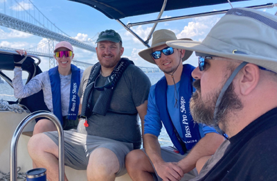
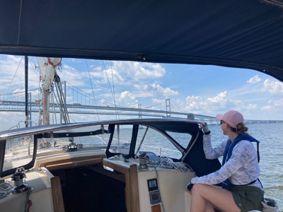
2022 Chesapeake Bay Cruise |
| Home
Purpose Course Descriptions School Yachts Schedule of Courses Ocean Training Cruises ASA Certification Registration Info Our Location Our People Contact Us |
DAY 1: The day started with an abbreviated orientation
with our vessel, Scholarship, as the students all had two previous classes on
the Island Packet 32. We spent more time reviewing ship’s systems, including
engine, battery management and fresh water supply. We then took an inventory
of food and provisions before creating a meal plan and provisioning list. Our
sistership, Acadame, was heading on a similar cruise, so we joined them for a
session on navigation and cruise planning. The crew was tasked with putting a
navigation plan together for our route to Annapolis the next day. Meanwhile,
Captain Andy went to the market for provisions and supplies. After lunch, we loaded the provisions, then reviewed and
finalized the navigation plan to Annapolis. We also loaded the cruising gear
(extra docklines, power cord, water hose, handheld VHF, etc). A look at the
weather forecast showed that this would be one of the cooler nights during the
August heat wave this week. The crew was eager to get underway and take
advantage of the forecast for lows in the low 70’s and a slight chance of
thunderstorms. After prepping and inspecting the boat, we were underway at
1700 headed under power for a secluded cove in Grays Inn Creek. We reviewed
techniques for anchoring with two anchors, then set up a forked moor: the
first anchor set to our south for the evening wind, and the second set to the
West for the predicted overnight wind shift. Anchored 1830. Capt. Andy
prepared our first meal aboard and we all settled in for the night.
DAY 2: FLASH! We awoke around 0030 to distant lighting.
Only a 15% chance of storms, they said! After checking the radar, it was clear
this one was big and heading our way. We took a reference bearing to the only
thing visible in the darkness, a light on a distant farmhouse. Hatches and
portlights were closed. Time to sit back and wait for it. The storm came fast
and furious with a lot of lightning and winds topping 50 knots. Heavy rain and
spray obscured visibility to the farmhouse, so we monitored our position using
a handheld chartplotter to see if the anchors were dragging. James and Erik
joined Capt. Andy on anchor watch and were ready to jump up on deck to
maneuver if needed. The wind had shifted to the North during the storm and was
now setting us toward a lee shore. Thankfully, with two anchors out, we held
our position until the storm had passed at 0230. What a lighting show and what
a way to welcome the class to cruising! We are rewarded in the morning with two bald eagles
perched nearby watching us eat our breakfast on deck. Weighing anchor in the
morning showed evidence of the anchors holding, as they were both well-set and
caked with thick mud. A bit of a mess, but we are good to go on the trip to
Annapolis. Underway at 0830. Caitlin is skipper of the day, with James taking
on navigator duties. Winds were light 5-8 knots at first, so we motorsailed
following the navigation plan out of the Chester River and into the Chesapeake
Bay. A brief try or two at sailing had us making less than 3 knots, so back to
motorsailing. The navigation plan is spot on and each mark appears on the
horizon as expected. Between Love Point and the Bay Bridge, we find the red
and white safe water mark. As we were passing under the bridge, a large cargo
ship was approaching, heading south out of Baltimore. We hailed them to
communicate our intention to stay east and outside of the channel marked by
the red and green lighted buoys. They shared their intention to cut the corner
on the red buoy that we were heading toward. Good communications. We gave them
more room and they passed about 100 yards abeam without incident.
By now, the wind had filled to a pleasant 10-15 knots
from the West, so again time to set full sails, making nearly hull speed, on
our way into the Severn River. Some tacking was necessary, which provided an
opportunity for the students to do some piloting and adjusting of the
navigation plan to conditions. After passing R”4”, sails were furled and
lowered. We looked over our shoulder to see our sistership, Acadame, only a
few boatlengths behind after a full day underway - both of us heading for the
main mooring field in Annapolis Harbor. Moored at 1502. We called for pumpout
and was informed the first available was 0900 tomorrow. Caitlin and crew began
working on the navigation plan to St. Michaels for tomorrow. Water taxi,
showers and dinner ashore make for a happy crew. DAY 3: Chris is skipper of the day, with Caitlin on
navigation duties. We reviewed the navigation plan and were planning on a late
start after pumping out. Upon seeing a large motoryacht leaving the Yacht
Basin fuel dock at 0800, we decided to go there for pumpout and ice, and get
an earlier start to beat the heat. Underway at 0850. Today’s forecast is
hot, humid with light westerly winds, so we are motorsailing again today to
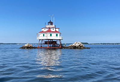
start. We passed Thomas Point and Bloody Point lighthouses, and drilled for
various emergencies, including rigging failure, medical emergencies,
collisions, etc. We verified our position along the way with two-LOP and
three-LOP fixes and determined we were close, but slightly north of the
planned course, and altered course accordingly. After entering the Miles
River, we saw a green can well to the south of our plotted course and double
checked the navigation plan. Sure enough, we should leave it on our port side
and altered course once more. We hailed the Chesapeake Bay Maritime Museum for
our slip assignment and were docked by 1450. Free time for showers, exploring
town and touring the museum before an early dinner at the Crab Claw. After
dinner, we review DR plotting skills using the day’s log entries,
time/speed/distance calculations, fuel consumption and range under power
calculations, then begin work on the navigation plan through Kent Narrows.
DAY 4: Erik is skipper today while Chris is in charge of
navigation. We check the weather: hot, humid, light southerly winds, expected
to build to 5-10 knots with a chance of thunderstorms late in the day.
Underway early at 0750 to make the 1030 bridge opening at Kent Narrows (near
high tide and slack current). On the way up the Eastern Bay, we have trouble
finding the G “1P” buoy. A daymark is spotted about ½ mile off the
starboard bow. Still no buoy in sight. Looking back at the Local Notice to
Mariners does not show any change, then we discover that the LNM we are
referencing is four weeks old. We get the most recent LNM on deck and sure
enough, green can “1P” has been replaced with a new daymark “1P”.
Mystery solved! Red nun “2” has also been replaced with a new daymark, but
not yet noted in the LNM. We are making good time and get to the narrows at
0955, hail the bridge and need only wait a few minutes for the opening. Erik
does a fine job navigation the swirling following current as we pass through
the drawbridge. We honor all the temporary marks to follow the shifting
channel out of the north side of the Narrows, then use a bearing to a nearby
water tower to determine when we can turn and clear the shoals. The wind has
picked up a bit, so once again, it is time to sail. Once at Lankford Creek
G”1”, we do some tacking and gybing drills and a surprise COB drill. The
entire crew was on the ball and had our float back onboard in short order
using a hove-to with motor-assist technique. From G”1’, there are no more navigation marks to get
into our next destination, Grays Inn Creek Marina, about two miles up around
the bend. The crew does a fine job navigating by soundings to stay in the
relatively deep (8 or 9 ft) water, only seeing it dip under 7 ft once, despite
being distracted by a dolphin or two on the way in. Docked along the T-head at
1445. Pumped out again. Sitting in the cockpit, we notice a large osprey nest
with two nearly grown offspring on a piling less than 50ft away, the mom and
dad teaching their young how to fly and fish. Time for review and questions in
preparation for the test tomorrow. Chris is our chef and we feast on
Spam-fried rice (much better than it sounds!). We toast the successful journey
as another round of thunderstorms approaches. This time, securely tied up to
the pier, we can relax a bit more than the first night at anchor. DAY 5: It’s a captain’s breakfast of pancakes and sausage this morning. We take our time departing and are underway at 0845. James is skipper with Erik on Navigator duties. Today is a relatively short trip back to Lankford Bay Marina. Once again, the forecast is hot, humid and light winds. The plan is to do more sailing drills if the wind allows, but alas, there is too little wind on this day. We head to LBM and refuel, then James takes us back into our home slip by lunchtime. It’s time to pack up, offload, clean up and then reflect on all that this crew has accomplished on this Chesapeake Bay cruise - well done! Captain Andy Barton
|
Web site design by F. Hayden Designs, Inc.