Home
Purpose
Course Descriptions
School Yachts
Schedule of Courses
Ocean Training Cruises
ASA Certification
Registration Info
Our Location
Our People
Contact Us
|
| Course: |
ASA103-104 Virgin Islands Coastal Cruise |
| Date: |
February 13-20, 2016 |
| Vessel: |
S/V
JEMA JOY - Island Packet 440
|
| Students: |
Derek and Tracy Eve, Harald Hefel, and Derick Moore |
| Captain |
H. Jochen Hoffmann |
Pre-departure
Preparation
Both Rita Hanson, MDS office director, and the Captain (yours truly) had
sent out cruise guidance in December and January to help my student crew prepare
for their ASA Basic Coastal Cruising and Bareboat Charter adventure. We also
concluded that a January on-line meeting would be helpful for the crew to get to
know one another, discuss meal planning plus possible destinations. All want to
explore the USVI. I arrived in Red Hook a day ahead of time to go over paperwork
with the charter company and – on Friday - do boat check-out with staff of the
Island Yacht Charter Company. My student crew arrived Friday afternoon, and we
went straight to work developing our meal plan, checking out the boat, and
enjoying dinner ashore. Since two of our shipmates have similar-sounding names,
we count first-name letters and all agree to call Derek “D1” and Derick
“D2”.
Saturday, February
13, 2016, Day 1
After breakfast at the aptly named “Latte in Paradise”, D2, Harald and
the Captain shop for provisions. Meanwhile, Tracy and Derek-D1 (who had already
taken ASA-105, Advanced Coastal Navigation) plot a nav plan circling Pillsbury
Sound clockwise to Christmas Cove via Caneel Bay. Tracy starts at G “1” Red
Hook Channel entrance on a course of 068º psc (per ship’s compass) past Two
Brothers rocks to the 60 foot depth contour west of Windward Passage. D1 lays
out course lines to Caneel Bay and thence to Current Cut at Great St. James
Island. We depart at 1115, practice maneuvers under engine, trimming to various
points of sail, and picking up moorings.
When we arrive at Christmas Cove in
midafternoon, we find that all mooring balls have been taken plus a large fleet
of anchored boats extends to the north off the mooring field. When we finally
see a patch of sandy bottom free of coral and drop anchor there (as required),
Harald who had offered to dive on the anchor reports that our heavy plow anchor
is skipping on packed sand. Anchor aweigh it is. Just as we are about to return
to Caneel Bay to find a mooring ball there, we see another sandy spot large
enough to receive two anchors. They will hold us firmly in place during the
windy night. After a refreshing swim, we enjoy dinner at sunset.
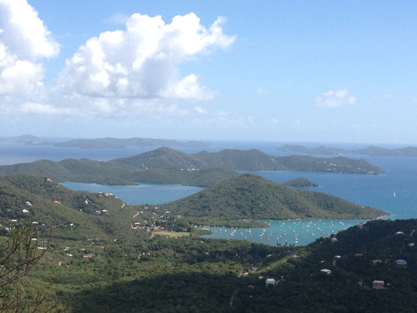
Day 2 Francis Bay
via Atlantic and BVI Waters
After breakfast, we look at area charts of different scales and devote time
unlocking chart mysteries with the help of the indispensable NOAA booklet Chart
No. 1. It is always amazing what wealth of information can be gleaned from a few
square inches on a nautical chart. As we examine the most recent LNM (Local
Notices to Mariners) affecting our charts and route, we note navigation aids
that are damaged or have gone missing – notably around dangerous Johnson Reef.
While Tracy and D1 do a pre-departure check and ready our vessel for sea, Harald
and D2 develop a nav plan from Current Cut into the Atlantic via Windward
Passage and from there to Francis Bay. They
are also among the first to check the VHF weather forecast. Winds will be up to
the low 20-knot range, which calls for a reef in the main sail.
Man overboard
drills (MOB) under engine power, later under sail, keep us busy as we also learn
to heave to with two sails or a single main sail. As we head for the last
available mooring ball in Francis Bay, a catamaran cuts us off and grabs it. On
to Maho Bay where we moor and then practice dinghy and Outboard engine
procedures on our way to the U.S. Park Service Pay Station. Three of our number
are excellent swimmers who are heading for the beach under the watchful eyes of
a kind “life guard” on board. Students have to “fight” Harald for a turn
at cooking dinner since he not only likes to cook, but also concocts excellent
meals. All are happy. D1 is still alert enough to start tomorrow’s nav plan
using Chart 25647-Pillsbury Sound with Soundings in feet.
Day 3, Rendezvous
Bay via Cruz Bay
After checking the weather forecast, and with Tracy as skipper, we motor –
at D2’s request - from Maho Bay to the Whistling Cay passage to get a good
look at the old customs and guard house ruins ashore. The stiff wind off Jost
van Dyke notwithstanding, all learn how to maintain the all-important “rescue
spot” during MOB maneuvers. We had decided to pick up a mooring in Caneel Bay,
dinghy in to Cruz Bay for lunch and inspect significant nav aids on the way. We
cruise by storied Carvel and Blunder Rocks and it’s only just past noon as we
reach Caneel Bay. But again: a “ball thief” on a catamaran overtakes us and
grabs the last free mooring ball.
We now motor into Cruz Bay, take note of the
danger mark Fl 4s 12ft 5M off a reef and then examine the harbor’s junction
buoy. It had been Green over Red for years but has now, in fact, been changed in
color sequence to Red over Green, marking the east channel to U.S. Customs the
preferred channel. We anchor in a crowded anchorage and the Captain decides to
stay onboard and do the boat watch while the crew dinghys into Cruz Bay village
for lunch. Upon departure, we note nearby Stephen’s Cay, notorious for its
rock outcroppings. With our eyes peeled on the depth sounder, we used the 30
foot depth contour and the distant channel buoy R “2” Fl R 4s to establish a
danger bearing, and we cleared the channel between Cruz Bay and Stephen’s Cay
and headed for Rendezvous Bay. We have this beautiful bay with no mooring balls
all to ourselves and practice once more setting 2 anchors off the bow.
Students take the ASA103 test and all pass, and then enjoy dinner and a
glass of wine in the cockpit.
Day 4, Salt
Pond
We begin the day covering the mechanical and electrical power plant and
waste system on board and how to troubleshoot each. Tacking east against winds
in the mid 20 knot range, seas 6 feet and against 2 knots of current makes for
slow progress. It’s a lesson in planning: extra time and energy are needed in
such conditions. As the crew takes bearing fixes, D1 spots a rare sight - two
whales breaching repeatedly a quarter mile to starboard. Tacking toward shore,
we augment bearing fixes with GPS Lat/Long danger bearings to keep us off reefs
and in line with a narrow Salt Pond access channel. With Harald at the wheel and
lookouts posted on either side, we safely negotiate the unmarked reef.
One of
the six local moorings is still left by mid-afternoon. Great! We find that only
mono hulls have ventured out into the prevailing wind, currents and seas. We
swim and snorkel with turtles then take the dinghy to shore to hike through
mangroves to the outdoor “Tourist Trap” food truck for dinner surrounded by
tropical trees and birds with a gorgeous view over Coral Bay. Harald plans to
visit here after our class and send a photo.
|
|
Click picture to enlarge |
Day 5, To Leinster
Bay
D1 and D2 start our nav plan to round the east end of St. John using Chart 25641
- Virgin Islands with soundings in fathoms. Tracy and Harald plot the final legs
into Leinster Bay. By now, students have learned how to convert headings per
ship’s compass into headings per True geographic North and vice versa. From
now on, all chart plotting is being done in True. Underway, D1 at the wheel, D2
monitors our progress closely. To keep us clear of Eagle Shoal, he revises our
danger depth contour from 10’ to 15 fathoms on a course of 044º True to the
channel between Privateer Point and Flanagan Island. While we are able to sail
the ordered course close hauled, bearings and our GPS danger latitude show that
current and leeway are setting us uncomfortably close toward Eagle Shoal. We
tack away and then resume our course on a close reach. We rig a preventer while
navigators Tracy then Harald order courses for a series of downwind legs that
take us into Leinster Bay.
We find a perfect mooring close to Watermelon Cay, snorkel,
and then dinghy to shore and hike, as Tracy had hoped we would, to the
intriguing Annenberg ruins, a sugar mill and rum distillery that operated for
150 years around the 1800s. Back on board, while Harald is preparing yet another
delicious dinner, others plot courses to circumnavigate St. Thomas tomorrow. D2
has picked Sir Francis Drake Channel to west of Hans Lollik Island; D1 plans to
round Outer Brass Island and through Dutch Cap passage; Tracy plans to pass
through Savannah Passage to Flat Cay; and Harald plans a route along SW Road and
up W Gregerie Channel, and finally past St. Thomas Harbor to Buck Island.
Day 6,
Circumnavigation of St. Thomas
Our navigators have plotted their rhumb lines in degree True and entered
estimated position marks assuming a speed of five knots.
During the first two hours down wind, we make half that distance in light
air. Time to check our progress with range and bearing fixes. The lookout spots
Hans Lollik Rock a distance ahead, danger depth contour 10 fathoms, and the helm
turns south to clear it. Winds have piped up to 15-22 knots from the east as we
round Outer Brass Island and head up toward Savanna Island Passage. A series of
short tacks follow to clear the passage prompted by strong counter currents.
Finally, we tack again to reach W Gregerie Channel. As we make our way out of
storied St. Thomas Harbor guided by the bright green mid-channel range on shore
near the Governor’s House, a sea plane takes off to our starboard. Exciting.
Once safely moored at Buck Island, there is time for another swim (lots of
turtles and a ray), a glass of wine, and yet another delicious dinner prepared
D2 and Harald.
Day 7, Red
Hook via Current Cut
Our final mooring ball at Buck Island had presented us a chafed pennant eye
without thimble. Rather than just threading our mooring line through the eye, we
choose to stack two sheet bends through the pennant eye which we finished with
two half hitches in order to transfer our load directly to the pennant rather
than the eye. It held us beautifully. On our way to Current Cut, the captain
takes the helm and we focus on text review.
In sight of Stephen’s Cay, we listen to Securite calls on
VHF Channel 16 alerting passing mariners to a salvage operation of two sailboats
that had struck the rocks surrounding Steven’s Cay near 18º18.198’N; 064º49.48’W.
In fact, we see one stranded sailboat still above water at the north end of
Stephen’s Cay and leaning toward the beach.
Sobered, we head for the crowded fuel dock at Red Hook
where D1 at the helm carries out perfect standing turns until an opening at the
dock allows the Captain to dock our good ship to take on fuel. Once in our slip,
it’s time for the ASA104 test (all pass with flying colors) and to clean the
boat as expected for bareboat chartering. Then we head for a final dinner
ashore.
Day 8, Red Hook
Again we enjoy breakfast at “Latte in Paradise” before final “broom
cleaning” the boat and packing our gear and emptying fridge and freezer to
turn the boat back to the owner in excellent shape.
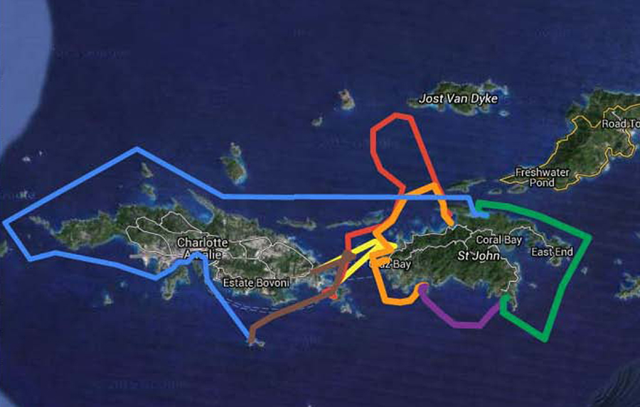
D1 has captured the outline of our routes on his tablet,
which I intend to attach here. What a great adventure for all. And what an
accomplishment on the part of the crew. Your captain salutes you – with thanks
and appreciation – and with good wishes for Fair Winds, always.
|

|
Click picture to enlarge |
Captain H. Jochen Hoffmann
On board S/V
JEMA JOY, February 20, 2016
Red Hook, St. Thomas, USVI

|