The following account is taken from the Blog we used
to track this cruise:
S/V NAVIGATOR, our
Island Packet 40 ocean sailing yacht, departed Norfolk Virginia at 1345 on May
27, 2016 after two preparation days in port with the entire crew. The crew
members are: Captain Tom Tursi (Skipper), Captain George "Nordie"
Norwood (First Mate), and student crew members Ellen Dawson, Walter Ried, James
Lyon and Carl Dickisson. NAVIGATOR will make the passage to
Bermuda via a non-stop ocean route. The cruise has an estimated distance of 670
nautical miles, and is expected to take approximately 6 days, sailing both day
and night.
We will follow the progress of NAVIGATOR and
her crew using a SPOT satellite tracker. One note on the SPOT transmissions: It
is far from infallible and a loss of signal is quite common. There have been
times where we had no position update for more than a day. Reasons can range
from a weak satellite signal, a something inadvertently shifting onboard and
blocking a clear view of the sky, or SPOT batteries getting weak. The crew will
check in with me electronically at intervals, and we will address such issues.
Also, sailboat tracks are effected by wind direction, current, etc and rarely
result in a straight-line course. I’ll post updates here, which will include
position reports from the crew... Rita
May 27, 2016 at 9:35 PM From Rita Hanson:
Bradley Mabe, a Maryland School graduate and weather expert is providing weather
guidance to the crew. I'll include his reports to the crew here on the blog,
beginning with those relayed in advance of their departure. Here is the first.
May 27, 2016 at 9:39 AM From Bradley Mabe
Subject: Wx 5/28 - 29
Tropical storm concern for the next 48 hours. Area of low pressure shows signs
of organization.
Movement WNW to NW This disturbance may make landfall and be out of your way -
will know more after 3PM reconnaissance data available.
Sat 5/28 - near Norfolk - Winds S to SE at 5 to 10 becoming E - SE 10 to 15
Sun 5/29 - Winds E - SE 10 to 15 becoming variable 15 to 20 late in the day;
rain and squalls probable as remnants of tropical low pass West of your
anticipated position.
Western wall of Gulf stream approx 17 miles off Cape Hateras.
May 27, 2016 at 3:35 PM From Bradley Mabe:
Subject: Weather Forecast Additional Information (5/27-29)
The National Hurricane Center has not issued any watches or warnings yet but if
they occur, they will be issued by 8PM.
Tropical low located about 450 miles southeast of Charleston, South Carolina as
of 3PM. Current movement continues toward the WNW. Shower & T-storm activity
continues to become more concentrated.
Will continue to advise through the evening / night / morning as I have new
information.
May 27, 2016 at 5:20 PM From Bradley Mabe:
Subject: Additional information: Tropical storm warning issued by NOAA
5 PM position 28.5N, 74.7W Moving WNW at 11
Projected to make landfall, southern SC Saturday evening then a turn ENE is
expected.
This storm should be away from your projected course to BDA
May 28, 2016 at 8:02 AM From Bradley Mabe:
Subject: Wx information (5/28-30)
Tropical Depression position center 29.9N, 77.0W as of 5AM Sat. Some
strengthening over night Max winds at 35 kts. Movement NW at 14 - projected to
make landfall on SC coast early Sunday. NAVIGATOR should be clear
of this storm. After landfall a turn to the NE is projected. (Note: As shown
below, Bonnie was forecast to turn across our path in a few days. This prompted
us to depart a day early to make distance to the east as soon as possible. The
winds which kept us north of our rhumbline shown in red were beneficial in this
respect helping to keep increased distance between us and Bonnie's expected
path.).
Forecast for your
projected positions:
5/28 - Winds variable SSE to SSW 8 to 10 building 10 to 15 later in the day
showers possible through the day
5/29 - Winds S to SE 10 to 15 showers possible from the S
5/30 - Winds S to SE 15 to 20
Stationary high pressure to your West keeps winds generally S thru the period
May 28, 2016 at 9:08 AM From S/V NAVIGATOR: Subject: 5/28/16 Status
Thanks to Brad for good weather news. We left a day early since Low looked to
have us pinned down for three days if we waited until Saturday. Initial eight
hours were great sailing with 18-22 knot winds from SE sailing 6-7 knots. Now
1-2 knots wind from all around the clock. Steering 140M under engine. All's
well. Had Dinty Moore for dinner last evening. Position 3641N, 7455W...Tom
May 28, 2016 at 5:24 PM From Bradley Mabe:
Subject: Wx forecast addendum 5/28
Tropical Storm Bonnie 31.1N 79.4W Moving NW at 10 knots; max sustained winds now
40 knots. I see no issues from this storm with NAVIGATOR 's
present track.
High pressure dominates the area along your course. Anticipate winds S to SE
with winds generally 15 to 20. A small front crosses your course late Monday or
early Tuesday bringing an increased chance of rain showers.
May 29, 2016 at 2:47 PM From Rita Hanson:
Received an all OK check in from NAVIGATOR at:
Latitude: 36.13937 N
Longitude: 72.28094 W
May 29, 2016 at 3:18 PM From Bradley Mabe:
Subject: Wx Information (5/29 -31)
High pressure to your East is the controlling Wx factor for
the next several days
Winds SE to SSE at 15 to 20 knots thru the period 5/29
through 5/31
Weak frontal passage late Monday 5/30 or early Tuesday 5/31
brings an increased chance of rain.
Tropical Storm Bonnie made landfall near Isle of Palms, SC
and is not a threat. Otherwise the tropics are quiet.
May 30, 2016 at 3:14 PM From Bradley Mabe
Subject: WX Information (5/30 - 6/1)
5/30 evening / night - winds SE 15 to 20 becoming 10 to 15
overnight
5/31 winds SE to SSE 8 to 10 becoming 15 to 20 during the
day
6/01 winds SE to S 10 to 15 - weak front approaches from SW
increasing likelihood of showers
Tropical storm activity is quiet.
May 30, 2016 at 6:44 PM From Rita Hanson:
Received an all OK check in from NAVIGATOR.
Latitude: 35.35287 N
Longitude: 69.06348 W
May 30, 2016 at 7:05 PM From Rita Hanson:We have not been receiving daily email status reports which
may indicate the crew is having email connectivity trouble which is not unusual
at sea. (Note: We were in fact having trouble with our new SSB radio not
transmitting after it had worked perfectly for the past several months. We
finally gave up trying to transmit, but were able to receive the USCG voice
weather forecasts from Chesapeake, VA and these we very helpful in addition to
the info we had from Brad at that time.)
May 30, 2016 at 10:09 PM From Captain Jochen Hoffmann ashore in Virginia:
OK messages from NAVIGATOR keep coming. My
latest was on 05/30/2016 at 21:18:28 EDT. Boat email connectivity may not be
working right now. Bradley's weather reports are telling and of interest to crew
and Blog readers alike. Even if crew does not get Bradley's Wx reports at
present, he had given them enough of a sense of TS Bonnie, which is now no
longer an issue. They are also picking up weather reports over their onboard
electronics to make course decisions. We see their course N of the rhumbline for
now since they have wind on the nose. (Note: Yes, we had wind on the nose for
most of the cruise to Bermuda forcing us way north of our desired route.)
May 31, 2016 at 10:22 AM From Rita Hanson:
Just received a Sat Phone message from Captain Tursi aboard
NAVIGATOR: All is fine; all crew are healthy; on schedule but
emails are not working properly.
May 31, 2016 at 6:08 PM From: Bradley Mabe
Subject: WX Information (6/1 - 6/3)
6/1 - Winds SSE to SSW mainly S 10 to 15 increasing chance
of rain
6/2 - Winds SSE to SSW mainly S 10 to 15
6/3 - Winds becoming SW 8 to 10
Scattered showers throughout the period
Daily highs around 80; nighttime lows 72 to 74
Tropical storm activity remains quiet.
June 1, 2016 at 12:19 PM From Captain Jochen Hoffmann ashore:
Based on Brad's weather forecasts
and a variety of NOAA weather products, we can see that so far NAVIGATOR
's winds have, generally, been coming from the direction the crew needs to go:
Bermuda. This is expected to change in the next 18-24 hours to allow for a more
southerly course toward Bermuda. But up to this point, to keep her sails full
and drawing, NAVIGATOR 's crew has had to stay north of their
desired rhumbline course. (Note: In fact the winds stayed mostly in an adverse
direction and we ended up about 80 miles north of Bermuda. So the last 24 hours
we had to tack south directly into the southerly winds in order to make Bermuda.
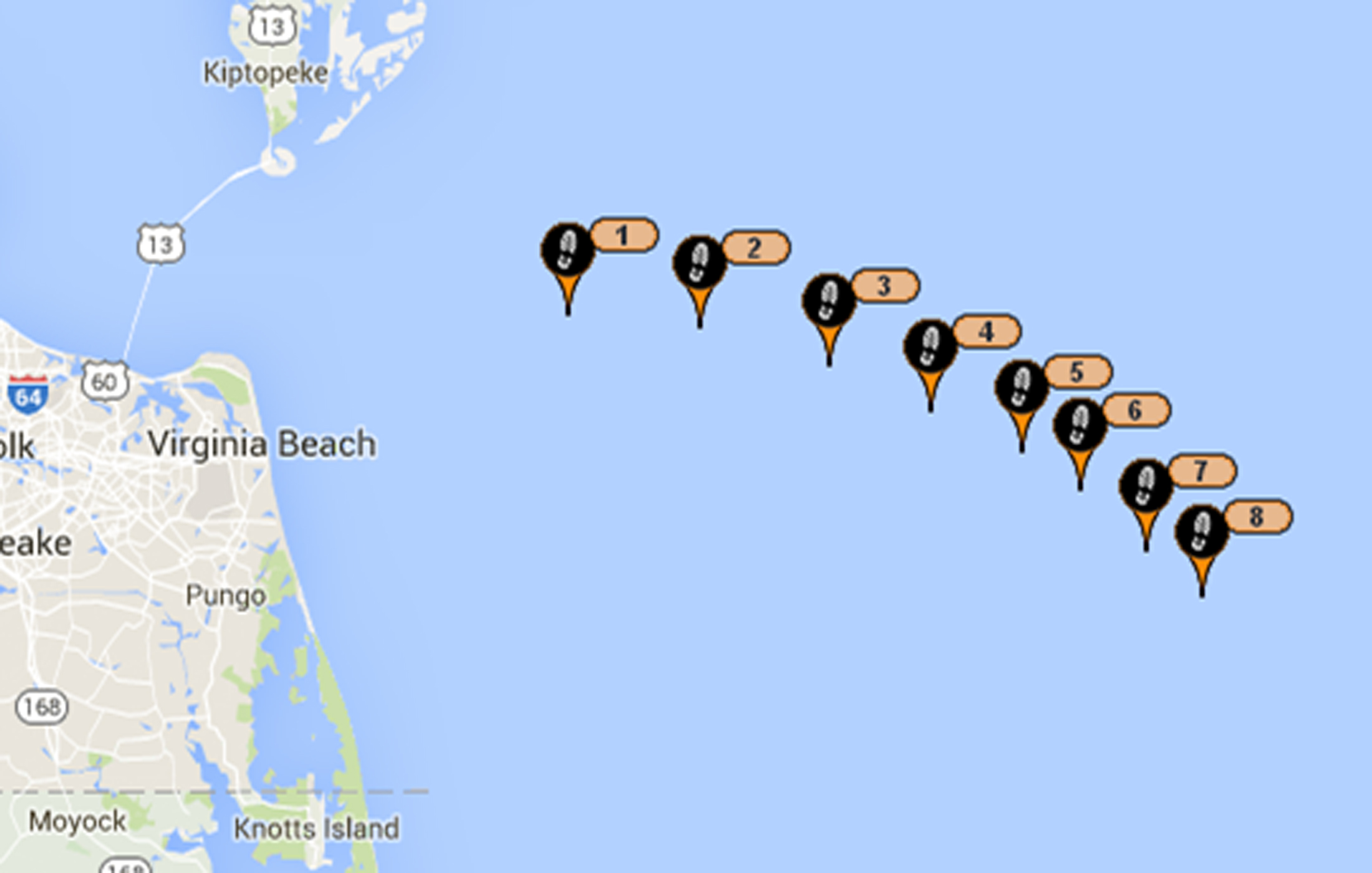
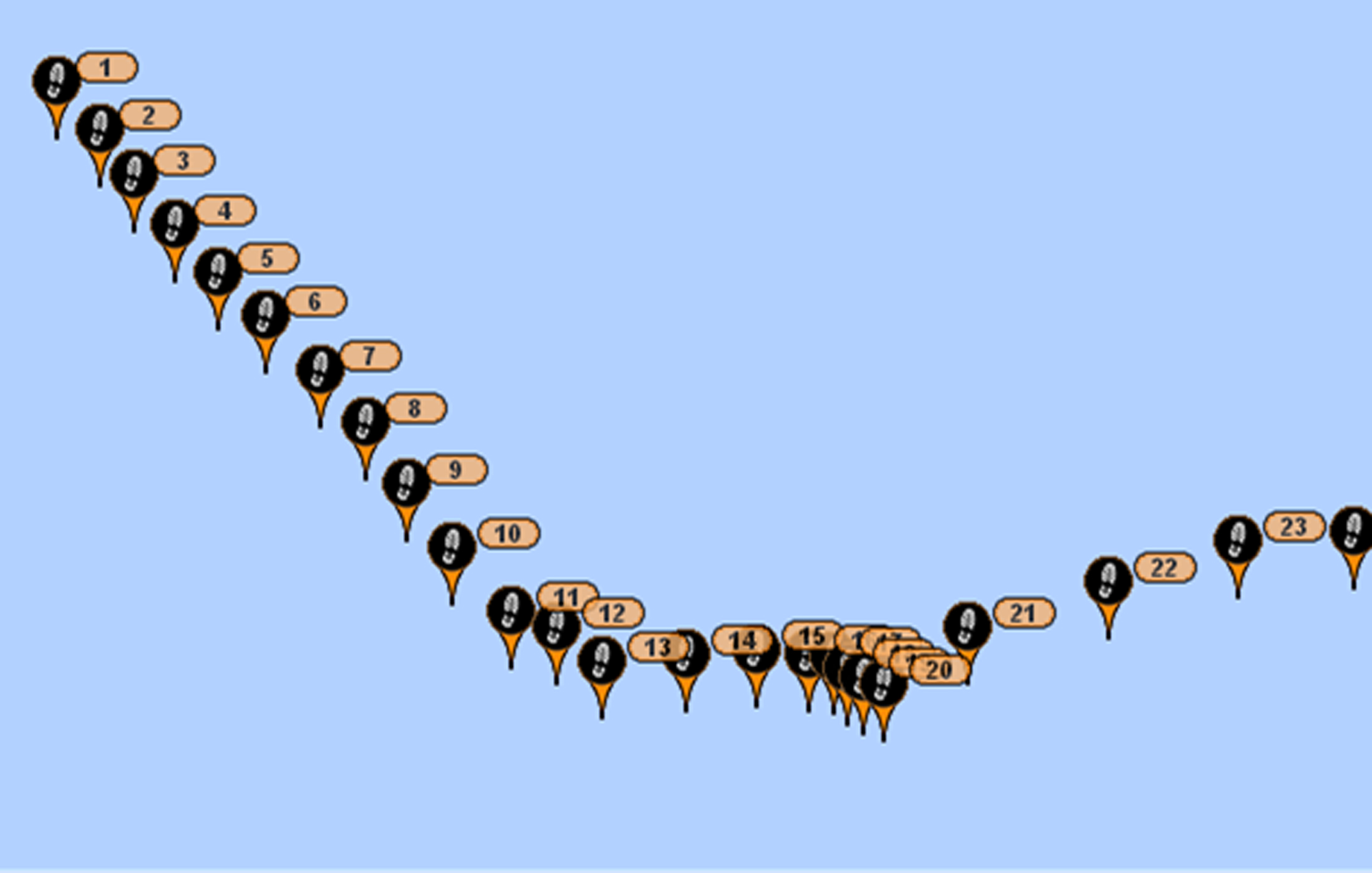
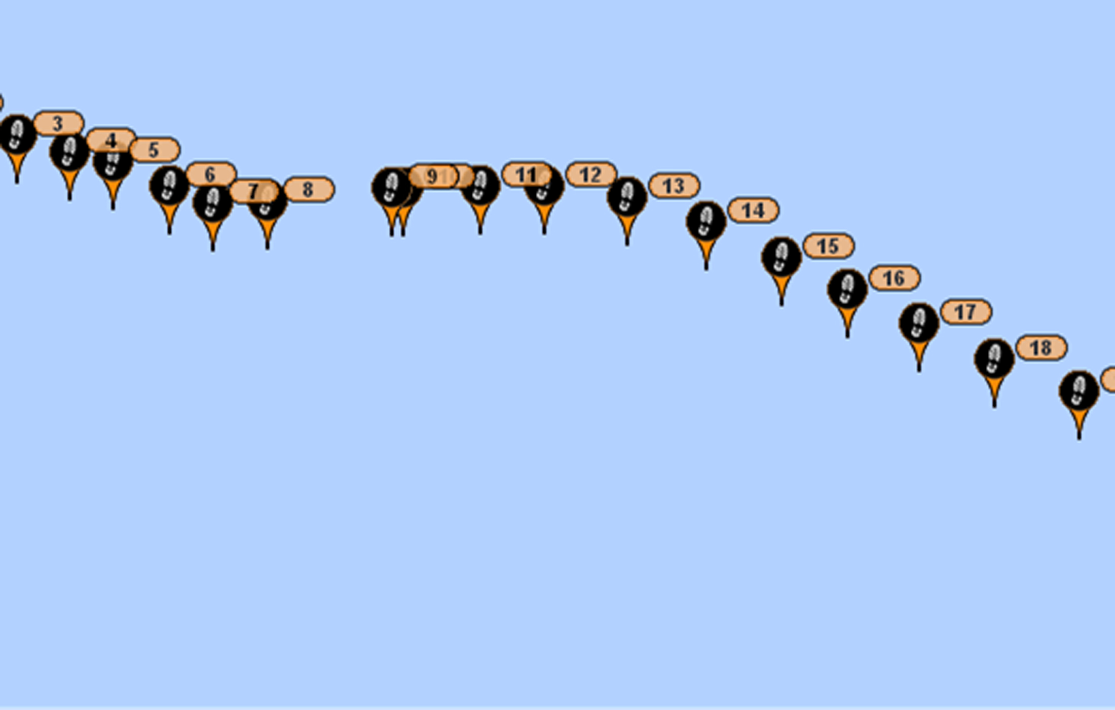
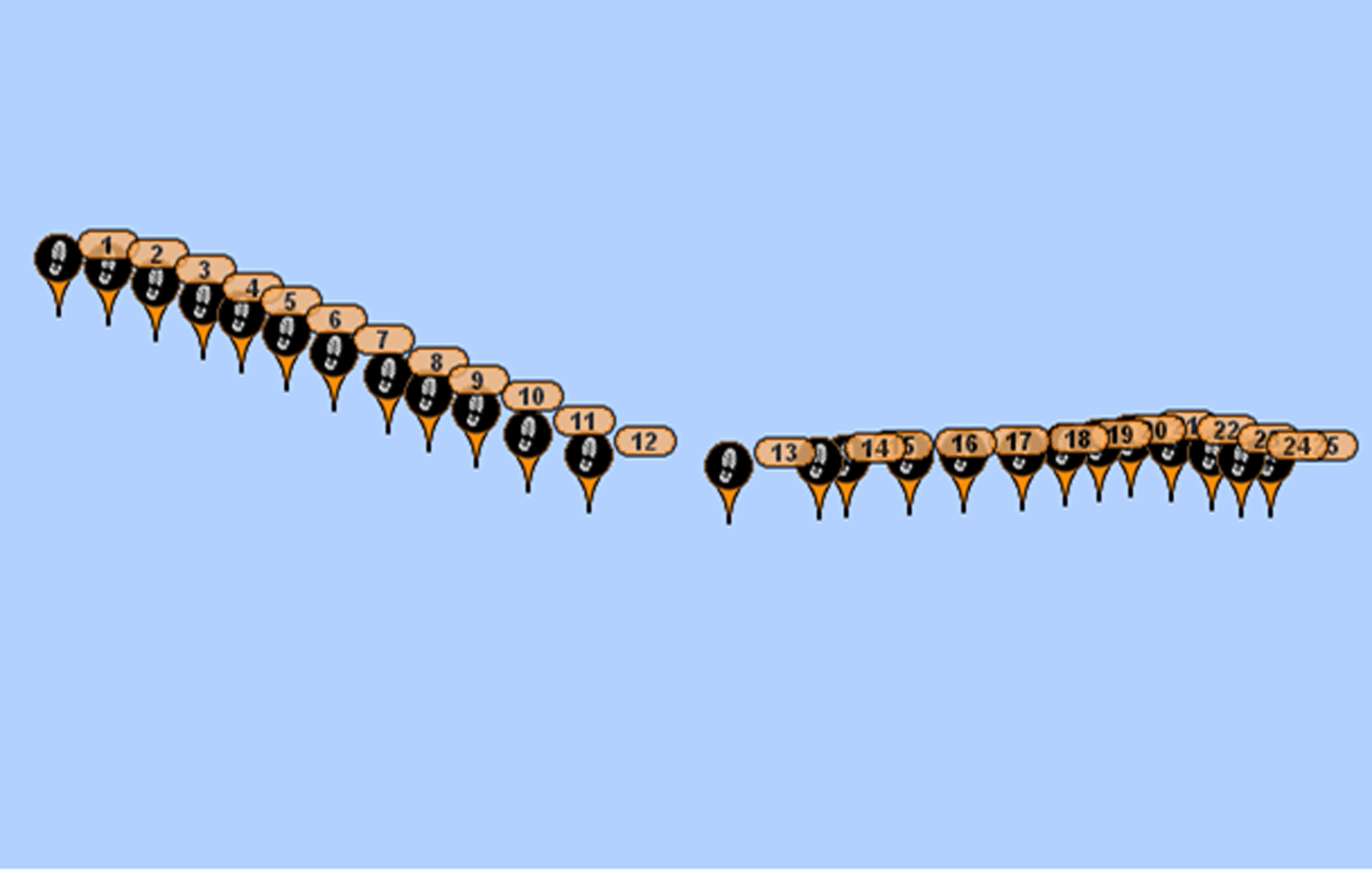
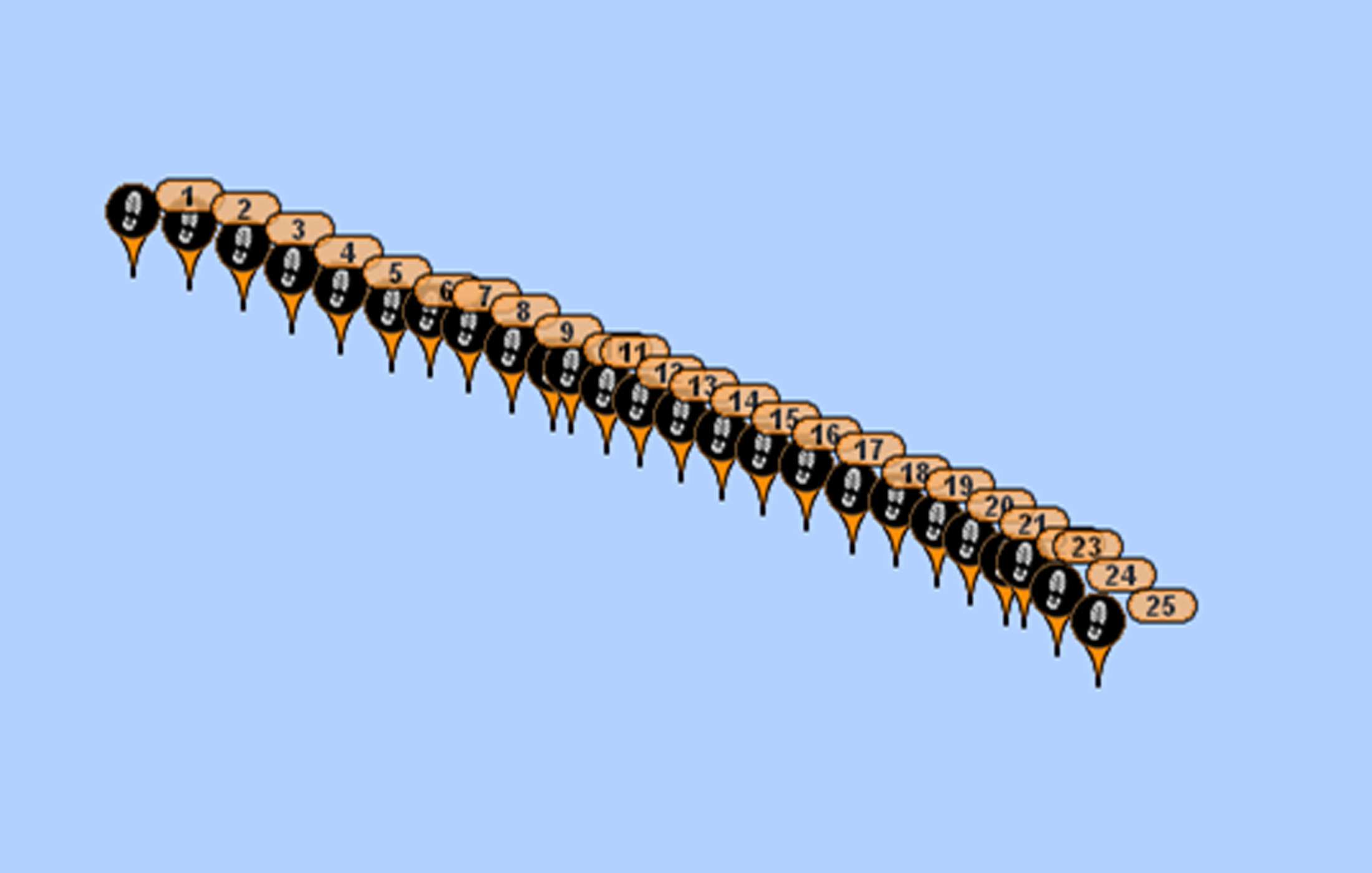
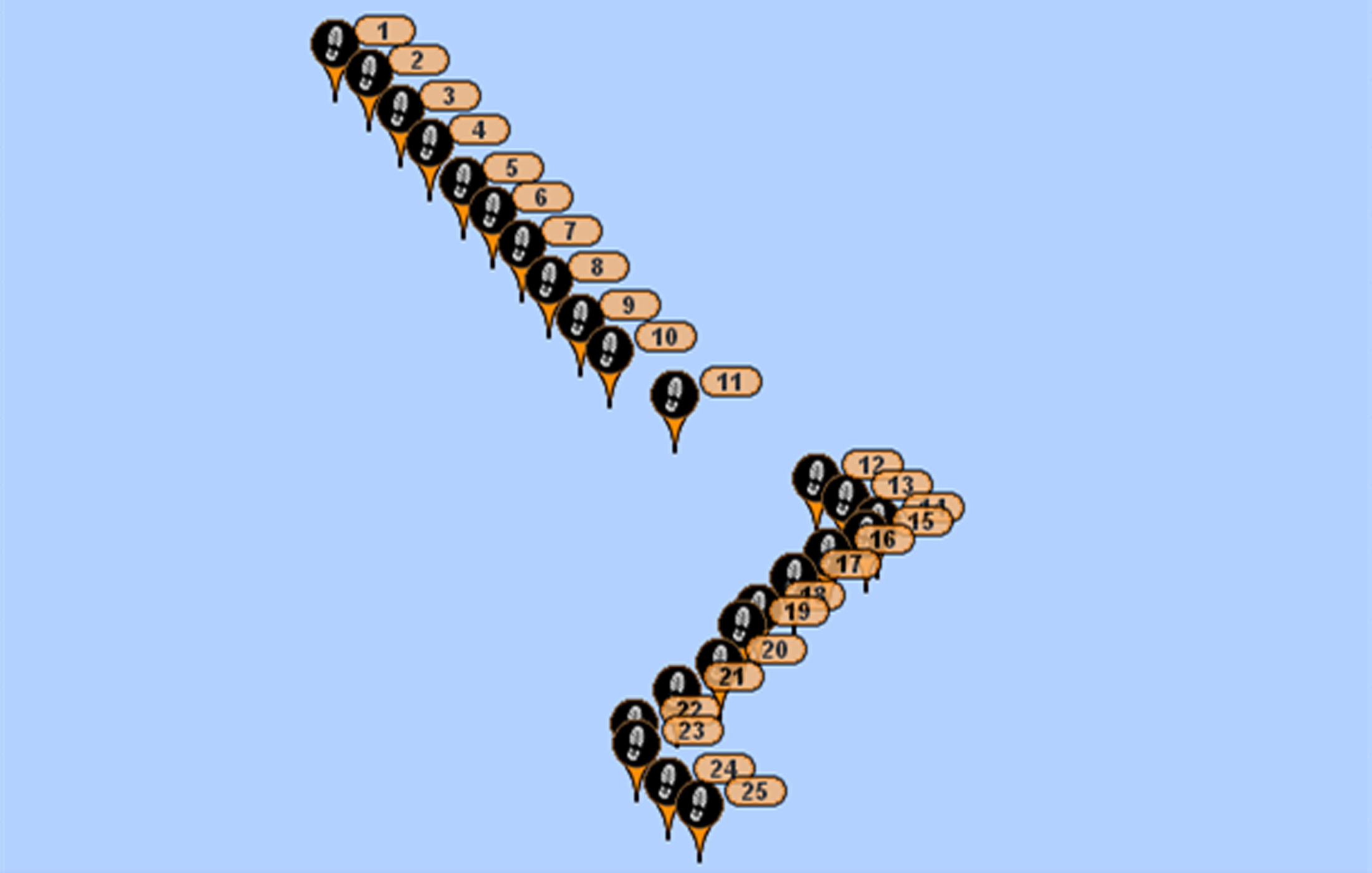
Below is a series of frames from the SPOT tracking device showing the actual
route sailed. Frames 6 & 7 show the tacks we had to make sailing south on
the last day.)
1
2
3
4
5
6
7
June 1, 2016 at 12:22 PM From Captain Steve Runals ashore:
While the wavy track will likely have resulted from Brad's
predicted wind shifts between SE and SSE, Captain Runals notes that prevailing
ocean currents could be a factor. There are on NAVIGATOR 's track
two prominent eddies (rotary currents) that have broken off the meandering Gulf
Stream weeks or even months ago: A blue cold water eddy (counter clockwise
current) and an orange warm water eddy (clockwise current). Each one will affect
the boat on her track - either slowing her down and moving her off course or
speeding her up in the direction of Bermuda. All are factors that make for
lively discussion on board during an ocean passage.
June 1, 2016 at 6:33:13 PM From Bradley Mabe:
Subject: WX Information (6/2 - 6/4)
6/2 - Winds S 8 to 10 a weak trough in the late afternoon
brings probable rain showers/ T-storms. Trough approaches from the SSW. Winds
increasing 10 to 15 gusts to 25 possible in T-storms.
Wind becomes SW 10 to 15 at night.
6/3 - Winds SW 10 to 15
6/4 - Winds SW 10 to 15
Chance of rain / T-storms through the period.
Daytime highs 80 lows 72 - 74
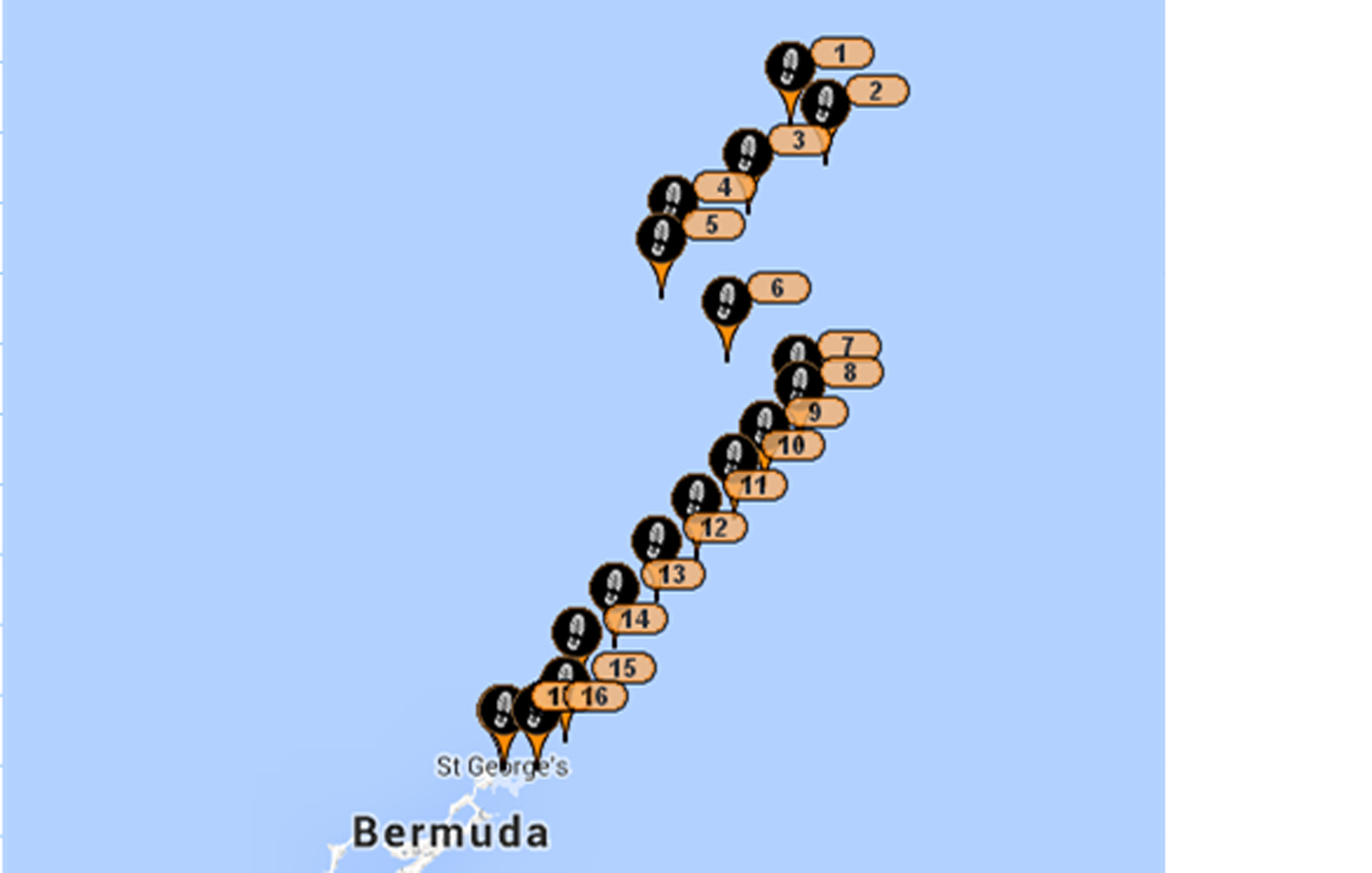
June 2, 2016 at 7:49 AM From Rita Hanson:
Family and friends... You can see by the SPOT track that NAVIGATOR
has made the expected tack toward Bermuda last night. Our best guess for an ETA
is between early evening and midnight today if all goes as expected.
June 2, 2016 at 7:17 PM From Bradley Mabe:
Subject: WX Information (6/2 - 3)
6/2 - overnight winds variable S to SSE 10 to 12 weak
trough described in earlier forecast moved more slowly than expected causing
some variation.
6/3 - Winds S at 20 early morning becoming SSW 10 to 12
later in the day
Your spot course shows you tacking from the N - sorry, I
tried to make it blow SW and put you close hauled. But I still can't persuade,
only predict.
TD Bonnie is back over water, strengthening and getting
better organized. Present movement is NE at 5 knots just off Cape Hatteras.
Models suggest a turn to the E over the next 24 hours. Bermuda is in little
danger as storm track is N of Bermuda, but may influence your return trip. I'll
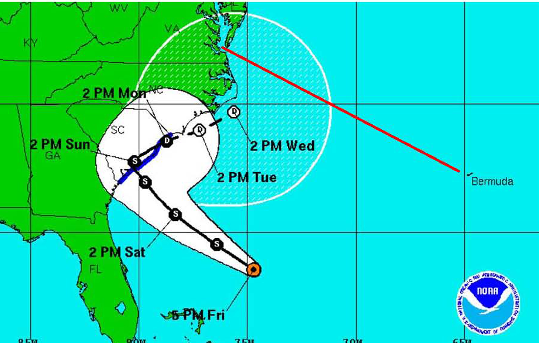
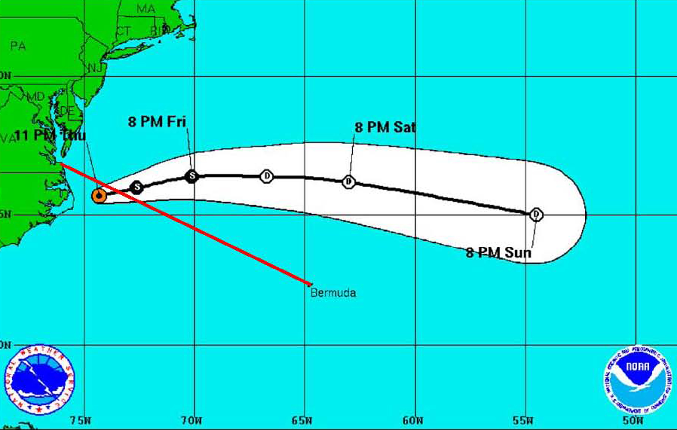
keep my eye on her. (Note: The image below shows the forecast path of TS Bonnie.
We arrived in Bermuda on Friday, 6/3 shown in this image, and this shows why we
were getting consistent winds from the S or SE. We were located to Bonnie's east
where we were getting the SE air flow that was feeding into her center.)
June 3, 2016 at 5:00 AM From Captain Tom Tursi aboard S/V NAVIGATOR We approached Bermuda over night from the north. Skies were
clear and visibility good. At 0300 we hailed Bermuda Radio on VHF16 to request
entry permission. They said we were on their radar and AIS and asked for details
of the boat, crew, emergency equipment, communications equipment, previous port
and next port after Bermuda. They gave us permission to visit Bermuda and
directed that we again contact them when we reached the Sea Buoy outside of Town
Cut Channel before entering.
The previous day we had made detailed navigational plans
for entry into Bermuda. And, now the crew was organized to transfer activities
from an ocean routine to a landfall focus where there are many potentially
dangerous object to pay close attention to, including other vessel traffic,
navigational aids, and water depths and rocky shoals. Jim was assigned as
Navigator to monitor route entry progress on the electronics and paper charts
below decks, and to check off NavAids and chart features as we progressed
inbound. Ellen was assigned to the Helm with strict orders to follow the
directed course. Walter was assigned as Deckhand with orders to perform deck
functions such as sail adjustments, line handling, etc and to maintain a
lookout. Carl was assigned as bow lookout with orders to maintain a lookout
forward of the beam for traffic, buoys and any other dangers and to sound an
alert as necessary. First Mate Nordie facilitated communications between the
Navigator and other crew members, and I maintained overall watch and perspective
on the ever changing situation.
At 0530 we reached the Sea Buoy, hailed Bermuda Radio on
VHF16, and received entry permission through Town Cut Channel with orders to
proceed directly to the Customs Dock for entry inspections. At 0615 we docked at
Customs and were cleared in promptly. We then proceeded to Hunters Wharf near
Dowling's Fueling Station and tied up along the eastern face of the sea wall
where we would be protected from the expected strong SW winds forecast for the
next few days.
Our crew was happy to complete this challenging cruise,
which had been extended by the adverse wind directions encountered during most
of the cruise. But, the plus side was that we had experienced many days of
exhilarating sailing under open ocean conditions... And, after all; isn't that
what it's all about?
Fair Winds my departing shipmates. My best to you in your
future adventures.
Captain Tom Tursi
S/V NAVIGATOR St Georges, Bermuda
Statistics:
Hours enroute: 155.5
Distance over water: 802 NM
Average Speed Over Water: 5.16 knots
Average Nautical Miles per Day: 123.8
Engine Hours Charging: 35
Engine Hours Propulsion: 31
Fuel Burned: 31 gallons of 90 gallons onboard
Fuel Rate: 31 gal ÷ 66 hours engine time = 0.47 gph at 1600 rpm
Water Usage: 80 gallons of 170 gallons onboard
Hours Pure Sailing: 155.5 - 31 = 124.5