|
|
2012 Bermuda Reports |
| Home
Purpose Course Descriptions School Yachts Schedule of Courses Ocean Training Cruises ASA Certification Registration Info Our Location Our People Contact Us |
22-23 May 2012, Tuesday-Wednesday 24 May; Thursday 25 May; Friday
26 May; Saturday And this is where the wrinkle came in: Tropical Storm Beryl
was churning about east of Florida and was forecast to turn and race to the NE
up the Gulf Stream just as we were planning to head SE across its path... Not
good. Tropical storm force winds can reach 63 knots, just below hurricane
strength, and they tend to intensify when tracking up the Gulf Stream with its
warm waters feeding the storm. So the dinner conversation this Saturday evening
was about the storm, the probability of our crossing paths with it, and whether
we should delay until it passed, which would be five days hence. The other option was to depart one day ahead of schedule,
and make maximum speed and distance south to get below the forecast track. This
could put us 200 miles away from the closest point of approach (CPA) as the
storm barreled NE and we sloughed SE at the mercy of its every whim. At this
distance, the forecast predicted that we could get 30 to 40 knots from the SE,
which is entirely manageable. Early departure meant we'd need to accelerate our
preparation schedule, and the most important remaining aspect of that was to
purchase our food and drink provisions, which we could do in the morning, and we
tentatively planned for a noon departure tomorrow. 27 May, Sunday Our navigation plan was to head S as fast a possible for a
waypoint ten miles E of Diamond Shoal Light out to sea from Cape Hatteras, and
there enter the Gulf Stream and make tracks to cross the stream as quickly as
possible recognizing that the stream current would push us to the NE toward our
theoretical rhumbline. On exiting the stream, we'd continue making a course more
south than east with an eye toward increasing our distance from the forecast
storm track, all of this fine planning of course being highly dependent on
prevailing wind direction. Watch schedule was set with David and Jeff on from 12 to 4;
Tom and Dan from 4 to 8; and Rich and Alexei from 8 to 12 all twice per day.
Along with this, Rich and Aklexei will prepare breakfast; Tom and Dan prep
lunch; David and Jeff prep dinner. At noon we departed Little Creek under sunny skies and a 12
knot breeze from the SE. Once rounding Cape Henry on the S shore of Chesapeake
Bay where it joins the Atlantic Ocean, we turned SE on a course of 155º True
(about 170º per ship's compass) which faced pretty squarely into the breeze
blowing from the SE. We had the sails up and were able to slant off part of the
time and gain some boat speed, but this was of little benefit to our speed
toward the Diamond Shoal waypoint.
From this departure point at Cape Henry, we began our ocean
navigation procedure by making hourly entries of course and distance through the
water in the Deck Logbook, and using these to make a dead reckoning plot on the
large ocean plotting sheets. This plot will be later used in conjunction with
celestial lines of position (LOP) to obtain position fixes by classical methods. 28 May, Monday
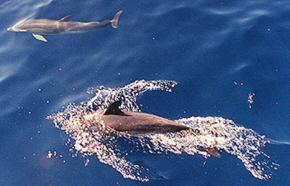
The wind direction from WSW blowing over the Gulf Stream
kept the stream waves low and nicely shaped, and we enjoyed a pleasant sail in
the stream with it's cobalt blue water and a visit by a pod of playful dolphins
at one point. By 2200 hours, the seawater temperature began to decline
indicating that we were exiting the somewhat diffuse SE side of the Gulf Stream
after an approximately ten hour crossing. At this point we changed course to ESE
heading more directly toward our Bermuda target waypoint, but staying a little S
of that track to continue to increase distance from the expected path of
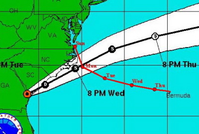
Tropical Storm Beryl. NOAA continued to forecast TS Beryl tracking along the East
Coast from Florida to Hatteras and then NE offshore from there, and passing N of
us by overnight Wednesday-Thursday with a wind strength of 50 knots near the
center. With our diverging paths, we expected to be about 200 miles from the
center of Beryl at our closest point. What we could not be sure of was: (1)
Changes in Beryl's track could bring her closer to us. (2) Possibility of
increased wind speed since it would track pretty much over the Gulf Stream with
its warm waters. (3) The timing of its arrival at CPA. 29 May, Tuesday
Winds continued moderate with 10-15 knots from the SW and
skies remained mostly clear. NOAA continued to forecast TS Beryl’s track as
before, and this would put its closest point of approach on Wednesday-Thursday
night. So we discussed plans for storm preparations, and my guidelines for this
discussion were that we would assume the worst in terms of track and wind
strength and prepare the boat and ourselves accordingly. With this in mind, we
set tomorrow afternoon, before dinner, as the time at which we would actually
complete these preps that the MDSchool Blue Book outlines and that we
light-heartedly discussed in port before leaving Norfolk. So tomorrow, theory
becomes reality. Conditions overnight remained moderate with winds SW at 10-15 knots, and we continued to make progress toward our Bermuda target waypoint on a course of 135ºT in order to gain a little more distance from Beryl’s track.
30 May, Wednesday
It took a surprising four full hours to complete these
preps... Not something you'd want to do at the last minute as a storm bears down
on you. But, we were using an abundance of caution for safety and for
instructional purposes. After this, we relaxed, had dinner and proceeded under
motorsail with only the storm trisail deployed... We were ready!!
31 May, Thursday
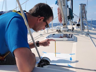
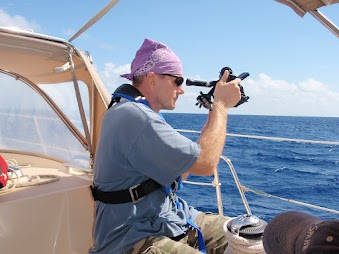
Again, we were blessed with clear skies and
steady SW winds, now 10 to 15 knots, and the crew broke out sextants to resume
practice of this time-honored art. They took additional celestial shots of the
Sun and the challenge now was to get two good shots, one around 0900 and another
around Noon, to allow plotting of a running fix, a technique of vital importance
to offshore navigation using dead reckoning and celestial methods. To do this,
it’s important to select shot times that will give good crossing angles of the
LOPs, the ideal being a 90º crossing angle, but angles as low as 60º are
generally considered acceptable. An 0900 shot will give a generally north-south
LOP depending on your latitude compared with the Sun’s declination (latitude.)
Consider this: If you are on the same
latitude as the Sun, it will be straight east of you in the morning, and the LOP
will be a north-south line. If the Sun is south of your latitude, which is the
case for our position today, the LOP will be tilted from NE to SW. At midday,
when the Sun is on your longitude, the LOP will be an east-west line. So, the
task here is to determine when the Sun will pass your longitude. The Nautical Almanac facilitates this by
including the time that the sun will pass the meridian of each time zone. But
since you are probably not precisely at the zone meridian, you will need to make
a time correction for this longitude difference. If you are east of the
meridian, the Sun will pass your position earlier than the meridian time from
the almanac. If you are west of the meridian, it will pass you later than the
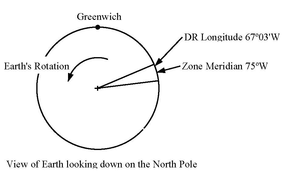
meridian time. So at midday on this date, we were at longitude 67º57'W. Dividing this longitude by 15º per hour (Earths rotational speed) equals 4.53 hours and rounding this up to a whole number of 5 means that we were in the 5th time zone west of Greenwich, with a zone meridian at 75ºW. And we are east of this meridian by 75º - 67º57' = 7º03' and this converts to 0.47 hours or 28 minutes, which is how much earlier the Sun will cross our longitude than the zone meridian. For this date, the almanac says that the Sun will cross the meridians of all zones at approximately 1158 zone time, which we generally know as Standard Time. Since we are keeping ship's time on Eastern Daylight Time, we add one hour to this and get meridian passage at 1258 ship's time. Subtract from this the 28 minutes, and find that the Sun will cross our longitude at approximately 1230 ship's time.
So, go up on deck at about 1225 with your sextant and
corrected wrist watch, shoot the Sun and note the precise time. Record your data
along with the ship's distance log reading and your height of eye above the sea
surface, and you will have an approximately east-west LOP which you can cross with the
roughly north-south LOP that you got by shooting the Sun at 0900. You'll cross
these LOPs using Running Fix procedures, which is a vitally important procedure
to master for using celestial navigation techniques at sea. By the way, what is
described here is not Local Apparent Noon, which actually takes multiple Sun
shots on deck, possibly as many as six or eight shots to get one LOP. But that's another discussion... All of our celestial navigators this day followed these
procedures and were pleased to see that a nice running fix resulted that
correlated fairly well with our dead reckoning plot... An enjoyable and useful
exercise. By the way, we're still heading to Bermuda with clear skies
and moderate winds from the SW at 12-15 knots. June 1, Friday Later, at about 20 miles out, we make VHF radio contact
with Bermuda Radio (There is an island there!!) to advise of our approach and
request permission to enter. They asked for identity of the vessel, crew
onboard, safety equipment, last port of call, and details of our communications
equipment, and give us entry instructions through Town Cut Channel into St
Georges Harbour.
As a pre-cruise task, Rich had researched the published
navigational approach guidance and prepared courses, waypoints and distances
needed for entry. Using this info, he prepared an approach plan and identified
the Nav Aids and critical landmarks needed for our after-dark entry. Port entry
is a potentially risky event at the end of a long ocean cruise when crewmembers
need to switch from an open-ocean perspective to a coastal perspective with its
close-in distances and rocky bottoms. We established duty assignments for this
including helmsman, navigator, visual bearing taker, and lookouts to
specifically identify key Nav Aids. All went well on our approach with no particular problems and we entered Town Cut at about 2200 and proceeded to the Customs Dock on Ordinance Island in St Georges Harbour. Courteous Bermuda Customs officials greeted us at the dock and completed all of the necessary paperwork and suggested that we take a berth alongside the quay to await morning light at which time we'd need to move before arrival of the ferry. We did so, and then trekked around the empty town in search of a pub to celebrate our voyage. Finally, we found a pub hosting a private party, and, feeling sorry for us, the owner offered us a spot next to the bar where we could quaff the local specialties as intrepid seamen do when in port. June 2, Saturday
And thank you Jeff and Dan for the albums of pictures and videos from the cruise several of which are included above. Captain Tom Tursi |
||||||||||||||||||||||||||||||||
Web site design by F. Hayden Designs, Inc.