|
|
2005 USVI-Norfolk Report |
| Home
Purpose Course Descriptions School Yachts Schedule of Courses Ocean Training Cruises ASA Certification Registration Info Our Location Our People Contact Us |
The crew assembled
onboard Halimeda at Crown Bay
in St. Thomas on Wednesday, May 4. After an initial orientation and briefing
about the planned passage and our preparation for it, we dined ashore.
Our crew consisted of Hal Sutphen, mariner, author and retired Navy
Captain as skipper; Billy Psimas, a computer expert from Northern Virginia as
mate; Elizabeth Hatton, a family practice physician from New York state and her
husband Mike Hatton, an oral surgeon; Wayne Mueller, a retired automotive
designer and woodworker from Michigan; and David Scheer, a retired electronics
specialist turned historic building restorer from North Dakota. Thursday was a full day
of preparation activity that included items such as inventorying equipment and
verifying its stowage, setting and inspecting all working sails, setting and
stowing in its ready-for-use mode the storm trysail, hoisting and stowing the
dinghy outboard, hoisting and stowing the dinghy on the foredeck, and inspecting
the engine, generator and electronics to ensure everything was operable and
ready for use. Briefings included
watch procedure, the boats daily routine during the passage and assignments
to watch and emergency bill duties. Friday saw continuation
of preparation activity, with David going aloft to inspect the rig, Elizabeth,
Mike and Hal doing the provisioning, Billy getting up to date weather
information and everyone participating in getting the boat fully secured for
sea. The crew did such an effective
job on the preparation duties that we were able to grant liberty for a few
hours in the afternoon for shopping in Charlotte Amalie and pursuing other
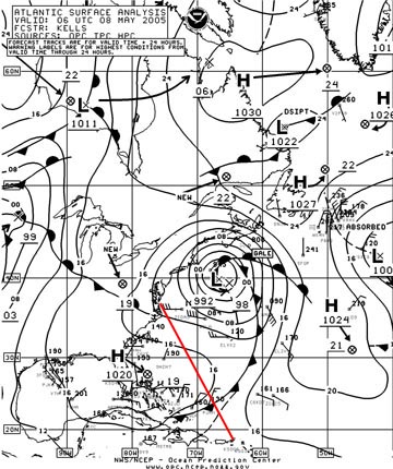
personal interests. HALIMEDA departed Crown Bay shortly before 9:00 am on Saturday, May 7.
We motored and motor-sailed upwind along the south coast of St. Thomas to
Great St. James Island, where we anchored briefly in Christmas Cove to inspect
the underwater hull. Dave, an avid diver, did the inspection and aside from
cleaning the speedometer paddlewheel and knocking a few barnacles off the prop,
he found the bottom in good shape. Departing
the anchorage at about 11:30, we quickly set sail and sailed north, passing east
of St. Thomas and entering the North Atlantic through Middle Passage, just east
of Thatch Cay. The wind was light
about 12 knots and there was a substantial southeasterly swell that made
the boats motion rather rolly. Fortunately,
only one of the crew was stricken with mal de mer, and prudent use of
medications helped speed the recovery process.
Being one day short of a new moon, the night was very dark and the stars
were spectacular including the Southern Cross, which is visible low in the
southern sky at St. Thomas latitude. Made
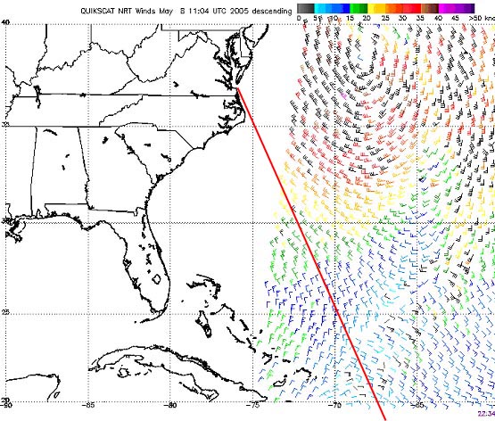
63 miles good by midnight. Sunday, May 8 found us
motor-sailing much of the day, as the wind went southerly and diminished in the
pre-dawn hours. The forecast called
for 5 or 6 days of light winds, so we altered our rhumb line track to run
parallel to the Bahamas for a few days until we were confident our fuel supply
would suffice to make the balance of the passage without stopping for more fuel.
We enjoyed a brief spell of northeasterly wind as we passed under an area
of cloudiness and light showers, but it didnt last very long.
The light wind and still rolly sea were causing a lot of motion in the
boom, and there were signs of looseness and wear in several parts at the
gooseneck, so a big project for the day was to install washers under the head
and nut on the bolt that serves as the horizontal pivot for the gooseneck and to
tighten the connections so the parts did not move and wear one another.
Made another 129 miles good.
Early Monday morning
the wind filled in from the north northeast and reached a sustained speed
sufficient to let us sail. With
clear, sunny skies and only a moderate ocean swell beneath the wind waves, it
was a great day to work on celestial navigation skills, and just about everyone
took a few sun lines. Best of all, the observations put us within 2 or 3 miles
of the positions shown on our GPS excellent results for navigators with
limited experience. After a
training session on distress signals, our major maintenance project for the day
was to remove, clean and check the cockpit manual bilge pump, which seemed
unable to get a suction on any water in the bilge. (The pump was perfectly fine
we later learned the problem was that the bilge was so dry there was
insufficient water to immerse the pumps pickup fitting that kind of
problem we dont mind having!) The
midday weather forecast from the Coast Guard high frequency radio station was
much more encouraging, so we altered course more to the north.
By keeping our engine speed low when the wind was too light to proceed
under sail alone, we minimized fuel consumption significantly. In late afternoon a fish struck the lure we were trolling
behind the boat, and it was a hard hit. When
we recovered the line, the entire brand-new lure was gone.
Made another 135 miles good. On Tuesday, May 10, the
wind was variable in strength but we managed to keep going under sail all day.
Although there was still a swell running, sea conditions had moderated
and the boats ride was much more comfortable.
Another clear, sunny day and another day with lots of celestial
navigation practice. The only
problem was that our latitude was not very far north of the suns declination,
so the sun was almost due east of us (producing north-south lines of position
from our observations) all morning; it quickly swung south of us at local
apparent noon and then stayed due west (more north-south lines) all afternoon,
so it was a challenge to get lines that crossed to form a fix.
We sighted several Bermuda Longtails today, and there were many petrels
around us, skipping along the surface of the sea.
We deployed the fishing rig again, but our slow boat speed reduced the
likelihood of a catch. After a
training session with the Starfinder, celestial practice continued with
evening stars. By 8:30 pm the wind
had died and we were motoring again. Only
made 103 miles good. Most of Wednesday was
spent motoring across an undulating sea, with a smooth, ripple-free surface atop
the remnants of old swells from the northeast. The sky was cloudless and sunny until late afternoon, when a
long bank of cumulus clouds arose on the northwestern horizon.
As we approached the clouds, the wind backed slowly from northeast to
west, but stayed very light. We could sail from time to time, but by evening we were under
power again. Lots of sun sights
during the course of the day, with impressive accuracy by all the navigators.
Made only 100 miles good. Thursday dawned clear,
sunny and windless, and the forecast called for another three days of similar
conditions. Although we had a lot
of hours of motoring, it had been at very low speed and our fuel gauge showed we
still had ¾ of our fuel. We did
some maintenance on the antenna connections for the single sideband radio and
thought we had it fixed since we successfully made contact with an amateur
station in Montreal, Canada. By
midday the forecast was being proved wrong as another long bank of clouds rolled
in from the northwest and this time it brought wind. It was light at first, but by sunset we were charging into
lumpy seas with gusts that hovered around the 20-knot level and we reduced sail
for the first time on the trip by rolling in some of the genoa.
As the evening wore on, the wind moderated, but we managed to make 128
miles good for the day. Shortly after midnight
the wind dropped below 10 knots again and we resumed motorsailing under a
brilliant display of stars in a clear and cloudless sky.
By daybreak on Friday, May 13 we had sufficient wind from the northeast
to sail. The cloud cover was
increasing and so was the wind. By
noon we were making better than 6 knots and the wind kept us moving nicely all
through the afternoon. This was our
best day of sailing since leaving St. Thomas and the weather forecast was more
encouraging so morale was up. Make
good 138 miles. Saturday brought
unsteady winds, and although we had to motor at times, we spent most of the
afternoon beam reaching to the north in 10-14 knot easterly breezes.
Boats to the north of us reported that their winds are light and
variable, so we were happy with our steady wind.
For the past three days we had been seeing hundreds of Portuguese
Man-o-War jelly fish, with their conspicuous pink/purple/blue flotation
bladders. Some were the largest Ive ever seen.
We also had recurrent visits from Bermuda Longtails and we saw petrels
almost every day. The sea
temperature had gradually fallen from the upper 70s to the low 70s, and as
we crossed 30 degrees north, the air had grown noticeably cooler than it was in
the tropics. With a prospect for
encountering more shipping as we approach the US east coast, the days
training topic was radar and radar plotting. The wind diminished at sunset and we resumed our
motorsailing, recording 123 miles of progress for the day.
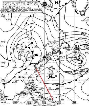
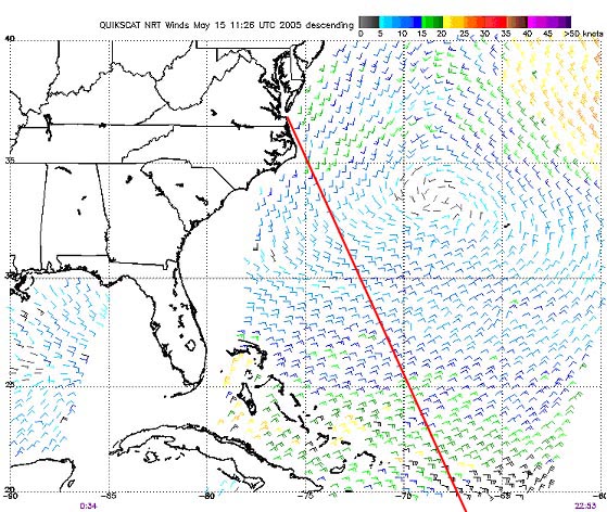
Sunday, May 15 found us
motorsailing over a curiously lumpy sea with light winds that were gradually
veering toward southeast. We headed
northeast to get a better wind angle, but this had only limited effect.
Around 2:00 am we gybed to a northwesterly heading to get on port tack
for the first time since leaving St. Thomas and also to move us westward where
we hoped to find more of a southwesterly wind.
Billy Psimas reported hearing small metal objects hit the cabin top
and investigation revealed that the fitting connecting the boom vang to the
bottom of the boom had sheered its fastenings.
We lashed the vang in place until daylight, when we do a better job of
securing it with additional lashings. We
also found that the cable connecting the single sideband antenna tuner to the
insulated backstay antenna was corroded and broken.
We replaced it with new cable and found that our radio reception and
transmission were both improved markedly as a result, even though a major solar
flare was playing havoc with radio propagation.
We spent the afternoon with the asymmetrical spinnaker set, but the wind
was so light we had to keep the engine running at low speed to keep the boat
moving northward. Although the slow
boat speed and the Sargasso weed that repeatedly fouled our lure minimized the
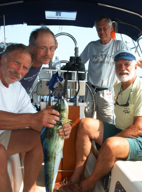
prospect for catching anything, we kept the fishing line out. This afternoon our efforts were rewarded when we caught a
nice size dorado. Nothing like
fresh fish to enhance the cruising menu! The
midnight fix showed we made 109 miles today.
Monday began with light
south and southwest winds that were strong enough to let us sail, but short,
lumpy seas gave us an uncomfortable ride. Distant
lightning flashes that seemed to be getting closer caused us to take a reef in
the main, but by daybreak we had encountered no squalls or hints of gusty wind,
so we shook it out again. A
current set us well to the west of our planned track, but this put us in a
position to ride with the Gulf Stream for 60 miles or so as we approached Cape
Hatteras. A long bank of heavy
clouds to the northwest was first thought to be hovering over the warm Gulf
Stream waters, but instead it proved to be the edge of a cold front that had
been forecast to stall in the vicinity of Cape Hatteras later in the evening.
The frontal zone was strangely docile.
We motored is virtually still air, running almost parallel to the front
as it crept eastward toward us. We
slipped between several intense areas of rain and found ourselves in notably
cooler air with a light west to northwest wind. We continued to motor northward,
looking to pick up a push from the Gulf Stream.
At 4:15 we were passed by a southbound tug towing what proved to be the
ex-USS GUADALCANAL. The
tug reported they were taking her offshore on a one-way trip, apparently
to be sunk for a reef or disposed of in deep water. At about the same time we were surrounded by an enormous
school of dolphin, both gray and spotted, and they put on a spectacular show for
us. At times there were a dozen or
more frolicking in our bow wave, and several did repeated leaps and
splash-landings. The school must
have included at least 50 of them and they stayed with us for nearly an hour. By late evening we were riding the Gulf Stream northward with
a light westerly wind. We had our
best day of the trip, making 141 miles good. Tuesday, May 16 began
with HALIMEDA sliding through
Gulf Stream water that was nearly 80 degrees, getting boosted to the northeast
at about 4 knots, making our speed over the bottom more than 7 knots most of the
time. We encountered a Gulf Stream
squall, with wind and rain, that caused us to reduce sail to double reefed main
and staysail, but it was short-lived and we were soon putting sail area back on.
We exited the Gulf Stream and the change was abrupt.
Water temperature dropped to 55 degrees, the color changed from cobalt
blue to greenish-black and the sea smoothed out nicely.
We deployed the fishing rig early and soon had a 30 bluefish on the
cockpit sole ready to be filleted. With
fresh fish in the refrigerator, we put the line out again while we ate
breakfast, and as soon as we finished eating we caught another blue. We put the line and lure back in the water to get it out of
our way and just as we were about to bring it in and stop fishing, a third blue
fish took the lure. All three were
about the same size and provided us a fish feast for supper.
With a pleasant 15 knot breeze from the northeast, we had a pleasant day
of sailing as we gradually approached the Carolina-Virginia coastline.
We made radar landfall about 4:20 pm and by midnight we were nearing the
mouth of Chesapeake Bay, having made 130 miles for the day. Wednesday, May 17. We entered inland waters for COLREGS purposes at 1:28 am and proceeded up Thimble Shoals channel, passed through the Chesapeake Bay Bridge-Tunnel and entered Little Creek at 3:27. We moored at Taylors Landing Marina at 3:49 am, having come 15 miles since midnight. Despite the hour, the crew was full of energy and immediately turned to the chores associated with the end of the passage: washing down the boat and sails, restowing everything in its assigned place, getting the dinghy off the foredeck and slung from the davits at the stern, cleaning the interior from end to end, filling water tanks and packing personal gear. As soon as the marina attendant arrived we refueled (having consumed only 71 gallons in our 119 hours of motoring). A call to Customs at 7:15 got us cleared in and then we were off for a shore-side breakfast at the local McDonalds, of course! Rapid phone calls identified available flights, travel plans were made and by noon the crew was on its way home. HALIMEDA was sitting in her berth and the first repairman arrived to start the process of getting her ready for her next trip: a passage to Bermuda. Captain Hal Sutphen
|
Web site design by F. Hayden Designs, Inc.