|
|
2002 Norfolk-USVI Report |
|
|
2002 Norfolk-USVI Report |
|
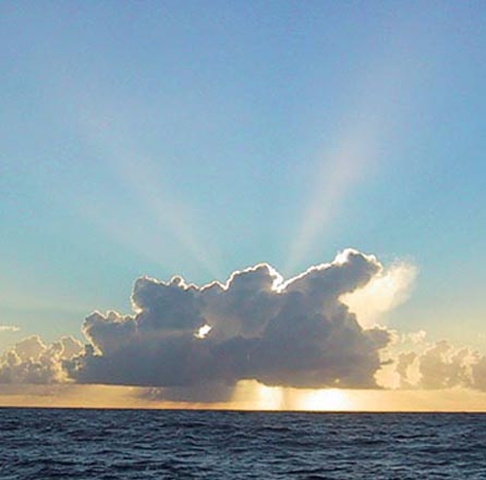
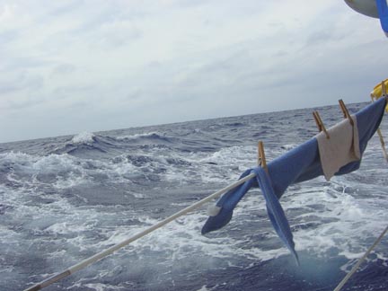
Sunrise enroute to St Thomas |
|||||||||||||||||||||||||||||||
| Home
Purpose Course Descriptions School Yachts Schedule of Courses Ocean Training Cruises ASA Certification Registration Info Our Location Our People Contact Us |
I arrived in Norfolk aboard HALIMEDA late on
November 9th at the end of an intermediate coastal cruising class that started
in Rock Hall, MD. Next day, my
coastal cruising students completed their ASA exams, packed their gear, helped
me clean up the yacht, and departed for their homes. They had been a good crew,
very pleasant to sail with and all very eager to learn which makes my job all
the more satisfying. But it was now time for me to shift focus to the very large
task that lay ahead; that is, a 1500 mile ocean passage from Norfolk to St
Thomas during Fall conditions with strong, quickly moving cold fronts, intense
low pressure systems and some inexperienced ocean crewmembers. I had five days before they would arrive onboard, and I set about preparing HALIMEDA for the upcoming challenge. I closely inspected the engine and generator, changed oil and filters, caulked some chain plates, applied water proofing to the bimini, renewed the genoa furling line and staysail sheets, organized navigational charts, updated the weather fax programming, had the life raft inspected and certified, cleaned the graywater pump strainer, replaced the generator seawater intake strainer basket, organized the rope and spare parts lockers, checked the integrity of hinge pins in all port lights, secured the dinghy and outboard motor for sea, renewed the polypropylene lines on the man overboard gear, bought fresh batteries for all portable lights, and verified that all necessary heavy weather gear was onboard and in proper condition.
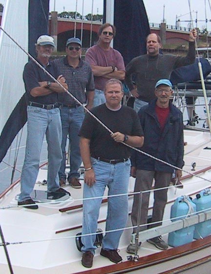
On November 15th, my ocean crew started arriving in the
afternoon. A cold front had passed our location the day before and the weather
was bright, clear and brisk. Steve Atkinson is a college English
professor on sabbatical, writing a book and decided to clear his mind with an
ocean sailing experience. Mark Johnson is currently retired from the
communications industry, recently completed the intermediate and advanced
coastal training cruises with The Maryland School and is taking this ocean
training cruise to complete his ASA certification levels. Bill Batchelor
is a dental surgeon who cruised from Bermuda to Norfolk with The Maryland School
in 1999, and joined this cruise for a longer and more challenging ocean sailing
experience. Craig Bilodeau is a USCG Near Coastal licensed Captain who
teaches at the basic sailing level for The Maryland School and joined this
cruise to sample ocean cruising. Lee Tucker, our First Mate is a USCG
Near Coastal licensed Captain and a Medical Doctor who has sailed with The
Maryland School on about ten previous ocean training cruises. Individually and
together, this was a fine group of crewmates to sail with on a long ocean
passage. We promptly began with the task of getting prepared for a
1500 mile ocean cruise. I assigned Bill as Boatswain, Mark as Boatswain Mate and
Navigator, Steve as Emergency Coordinator and Craig as Engineer. Each had
specific checklists to accomplish in getting ready for sea; these lists are part
of The Maryland School's Offshore Training Cruises Manual and have been
developed over a number of years while we conducted more than 120 ocean training
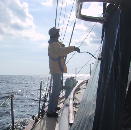
cruises. First Mate Lee worked with the Boatswains in reviewing all deck gear
and the sailing rig. I worked with the Engineer, Emergency Coordinator and
Navigator inspecting and preparing their areas for sea. This effort would take
about 2-1/2 days to accomplish before departing port, and by that time we should
know every inch of HALIMEDA, spare parts, tools and normal and
emergency operating procedures. Also, we'll get to know each other and begin to
develop the personal relationships necessary for successful operation of a small
yacht at sea for an extended period of time where the essential motto is:
"Take care of your ship and your shipmates, and they will take care of
you."
Saturday, November 16 Sunday, November 17
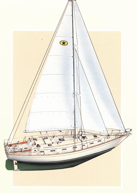
HALIMEDA is equipped with the following sources for obtaining weather data: a Furuno Weather Fax with built in SSB
receiver, an ICOM 710 SSB radio, two VHF radios, and a NAVTEX receiver, and each
of these units has a separate, dedicated antenna. The VHFs receive the NOAA
voice forecasts for coastal waters out to ten miles or so. NAVTEX receives
text forecasts on an LED screen out to about 200 miles. The SSB radio receives
voice forecasts for ocean waters and is of virtually unlimited range depending
on atmospheric conditions. And, the weather Fax receives graphic images of
weather systems over large geographic areas including the high seas and entire
continents, and is also of virtually unlimited range. We closely monitored these weather sources during this
preparation period to ensure departing in optimum conditions. It has been aptly
said that you can choose your cruise departure weather but cannot usually choose
your arrival weather. Generally, leaving from the east coast of the US and
sailing south or southeast, it's ideal to leave on the heels of a low pressure
storm system with a trailing cold front so as to have strong following winds and
seas. This enables you to make maximum distance during the initial few days
before the next storm system inevitably comes through. Also, it allows the crew
to acclimate to sea-conditions before conditions worsen. In late November, this area experiences the frequent
passage of quickly moving lows pressure storm systems and strong cold fronts,
which regularly produce winds of 30 knots or more and seas of 15 feet or more.
Threading the needle between these systems is desirable to minimize discomfort,
injury and equipment damage, and a keen analysis of developing weather
conditions is necessary to achieve this. So, during our prep days, we keep a
close watch all of our weather sources as well as shoreside TV, Internet and
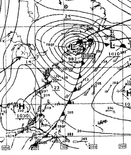
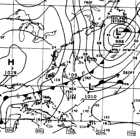
newspaper weather images and forecasts. On November 16th, a Low developed in the Gulf of Mexico and
was forecast to reach Norfolk within 24 hours. It crossed us on November 17th
and raced to New England by the next day producing gale-force winds and 15 foot
seas in the Gulf Stream outside of Cape Hatteras and the season's first winter
blast of cold, ice and snow in the northeastern US. By November 18th it
intensified into a severe storm over Nova Scotia and charged off to England
trailing with it a beautiful cold front, which crossed us in Norfolk with 20
knot northwesterly winds and clear, cold weather. Ideal for departure on our
planned date, and we were ready. Monday, November 18
Our route plan called for us to sail a rhumbline of 136
degrees True to a point 300 NM south of Bermuda, and then turn south toward St
Thomas. Strong easterly Trade Winds usually develop in December in the tropical
latitudes, and we wanted to get east to our final longitude before we were too
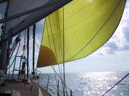
far south and into the Trades. Thus, this banana shaped route. Another factor related to route selection is that we'll be pushed about 30 NM to the NE when crossing the Gulf Stream less than a day from now, so we favored remaining south of the rhumbline prior to then. We passed Cape Henry at the Chesapeake Bay entrance at 1250, set the main and genoa sails and set a course of 150 degrees Magnetic; at 1630 we headed up to 165 degrees M to improve sailing performance. Winds lightened as evening fell and we began motor sailing to maintain speed. During the night winds continued to lighten and we struck all sails and motored as I wanted to get across the Gulf Stream before the next weather system came through. By midnight we made 58 NM since departing Cape Henry. Tuesday, November 19 At 1130 we entered the Gulf Stream as confirmed by a
20-degree jump in water temperatures and a three knot current setting to the
NNE. By 1900 we were out of the Stream as noted by a 10-degree drop in water
temperature and current of less than one knot. Winds were now NNW at 10 to 12
knots and we sailed close hauled on port tack and made 123 NM in the 24 hours to
midnight Wednesday, November 20
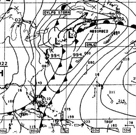
At mid-day, the weather fax printout showed a low pressure
system developing over Mississippi, and predicted it to move east toward
Florida; it also predicted that the high pressure air, which had dominated our
weather for the past two days, would quickly move NE to Nova Scotia. This
suggested a possible encounter with that low in subsequent days. And, the 1700
voice weather from NMN in Portsmouth, VA forecast a low pressure system reaching
the Virginia Capes by Thursday night and Friday and predicted gale force winds
offshore on Friday and Saturday. By midnight we made 141 NM for the past 24
hours. Thursday, November 21 Friday, November 22 Saturday, November 23
During the day, winds clocked to NW at 15 to 20 knots, and we headed up to a
course of 190 degrees Magnetic to keep the sails drawing and maintain boat
speed. By afternoon skies began to clear and the barometer rose by 10 millibars
as the first cold front passed over us. We continued with excellent sailing and
made another 157 NM by midnight. We were now about 150 NM from our waypoint at
27N & 65W.
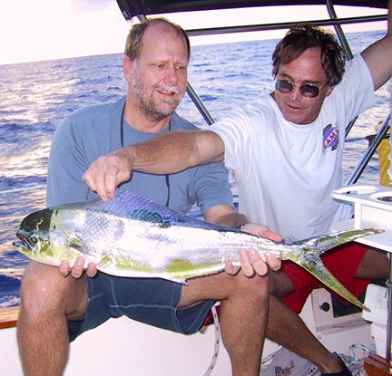
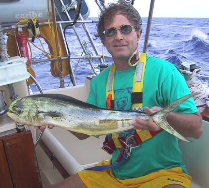
Sunday, November 24 Dorado!! At 1600, the fishing line that Lee had been dragging faithfully since we left Norfolk, came to life with a strike. Lee grabbed the rod and played the fish in as the helmsman slowed the boat's speed by pinching up to windward. Lee deftly boated a beautiful ten pound dorado that danced in the cockpit with glistening colors of green, yellow and a salmon colored stripe. Bill held it with his foot while I poured some vinegar into the gills to dispatch his spirit to King Neptune. Lee then, with surgical precision, skinned and filleted our catch with a sharp fillet knife supplied by Craig. By 1700 we were enjoying a delicious dinner of Mahi-Mahi, black beans and rice plus a salad with feta cheese. A perfect meal and a perfect evening, and by midnight we had made an additional 142 miles.
Monday, November 25
Tuesday, November 26 Wednesday, November 27 Thursday, November 28
At 8:00 pm I leave instructions for the night watch to wake
me before passing south 18 degrees-35 minutes north latitude. The purpose is to
ensure that I'm on deck as we approach landfall. As of midnight we made 153 NM
during the last 24 hours, and we were 28 NM from our arrival waypoint.
Friday, November 29 We're heading straight for the west end of St Thomas and
the off-lying Savana Island. We'll be conservative and round Savana, rather than
pass between it and St Thomas, and turn East toward Water Island and West
Gregerie Channel leading into Crown Bay. I've assigned the Conn to Bill for port
entry, which means that he'll be in charge and calling the shots during this
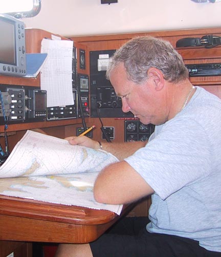
delicate phase of arrival. Mark will continue as Navigator with the assignment
to plot our GPS position on the chart at 5 minute intervals plus plot compass
bearings to land objects as a confirmation of our position. Steve will shoot
compass bearings of land objects and help identify landmarks. Craig will serve
as helmsman, taking steering orders from Bill, and maintain a general lookout.
Lee will serve as bow watch and general lookout. Landfall after a long ocean passage is fraught with it's
own special kinds of hazards as the crew needs to transition from ocean-attitude
to coastal-attitude. In the big, wide ocean it usually doesn't matter if you're
a few miles this way or that way. But in coastal, a few hundred feet may make a
huge difference. Many mistakes can occur
because crewmembers are not fully synchronized with the change in ship motion,
timing, distances, duties, procedures and other factors. Fatigue and the
euphoria of port arrival can distract crew from their immediate duties, and
boisterous chatter about parties ashore can overwhelm important communications
between crewmembers. And in an area like this, running aground on a rocky or
coral reef can sink the boat. The team was fully
prepped for the duties at hand and they worked like champs. We made the turn at
Savana Island, headed east into Southwest Road and furled sails, then continued
east toward West Gregerie Channel. Within a mile of Crown Bay, Mark took over
the helm for entry into Crown Bay. About this same time we were overtaken by a
dozen power yachts roaring toward Crown Bay, and they overwhelmed the radio
channels with requests for slips and entry instructions. We just circled for a
half hour until it quieted down and then asked for permission to enter and go to
the fuel dock, which was promptly granted. Mark expertly brought us in to the
fuel dock and at 1000 hours all clambered ashore to kiss the dry, steady earth.
We topped up with 60 gallons of diesel and proceeded to out slip. Some statistics for
the cruise: Elapsed time 10 days & 23 hours. Distance 1660 nautical miles.
Average speed 151 miles per day. Fuel used 60 gallons for the main engine and
generator. No injuries. No serious equipment problems. Altogether, a happy
ending. Captain Tom Tursi |