|
|
2018 DELMARVA Reports |
Home
|
Pre-departure
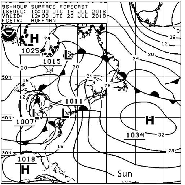
Preparation: The strong SE winds forecast
for the Delaware Bay make a trip down that Bay with its funnel shaped entrance
and strong currents very challenging, so we discuss the option of heading down
the Chesapeake Bay first. We
can expect to still have strong SE to S winds but the current is less and the
fetch far more limited. Once the crew is aboard and gear stowed, we head off for
a crew dinner. Despite Rock Hall
being crowded with weekenders, we find a relatively quiet place at the Harbor
Shack restaurant and continue getting to know each other over a very
satisfying dinner. Back aboard we
review the ASA106 standards, assign preparation responsibilities and inspect
personal safety gear. An early
bedtime is a welcomed end to the day. The
decision to go south will be based on the updated weather forecast at noon
tomorrow and discussion with Tom Tursi. Saturday: Day 1
– Boat and crew preparation and detailed navigation planning: The noontime long range weather forecast confirms that we will face very strong gusty SE to S winds in Delaware River and Bay on Tuesday/Wednesday, so after conferring with Tom Tursi, who will be monitoring our travels, the decision is made to head first south down Chesapeake Bay on a counter-clockwise route around the DMVA peninsula. After reviewing individual pre-departure tasks, we take the next several hours to complete assigned tasks. Bill works with the Captain in developing a navigation plan from Lankford Bay down the Chester River to Annapolis. First Mate Tom works with Etta engineer, Ryan bosun, and Adrian emergency coordinator as they complete their assign pre-departure tasks. Once their tasks are complete, they support Bill by reviewing the Light List, restrictions and nav rules supplements found in the Coast Pilot and cruising guide, Local Notice to Mariners (LNM), determining the state of the current and get the short term weather forecast. The extra time for planning provides an opportunity to work each area in detail. We finish all this in time for First Mate Tom to review and assign responsibilities for onboard emergencies before heading ashore for dinner.
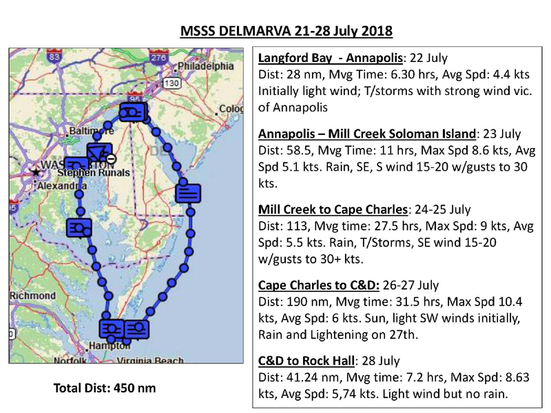
Day 2 - Lankford Bay to
Annapolis: Around Love Pt a pod a dolphins welcomes us as we make
our way toward the Bay Bridge and a sky filling with clouds.
South of the bridge the wind builds and heavy rain begins.
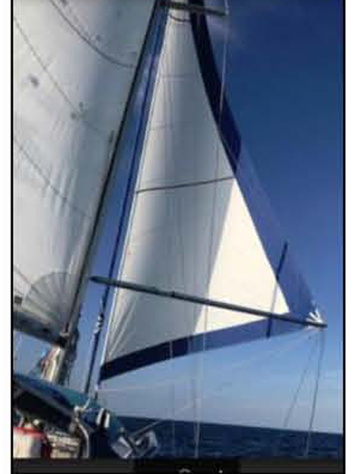
We take the opportunity to do some sailing in this heaver wind before
heading into Annapolis to pick up a mooring. Once secure, the rain lets up and we head into town for
dinner at Chick Ruth’s and a little walk about. Back aboard, Etta takes the lead in planning our trip south
to an anchorage on Mill Creek in Solomons Island with Adrian, Ryan
and Bill reviewing the supporting navigation publication: LNM, Light list,
Cruising Guide and Tide/Current tables. The
forecast is for SE winds 15-20 with gusts to 30 knots and rain with T-storms. We
drift off to sleep as the rain again begins to fall.
It’s been a good day to begin working on crew team development and
understanding of boat systems. Also important is where to store wet foul weather
gear.
Day 3 – Annapolis to Mill Creek, Solomons Island: While we are able to take advantage of an ebb current, the SE winds blowing against the current increases the already 3 to 4 ft waves making them short and choppy. By the time we reach the Patuxant River the waves will be easily 5 to 6 ft in height. Heavy rain with strong gusty winds mark our passage with few other boats making an appearance. As we approach the Cove Pt gas platform we see another sailboat working its way south under reefed main and headsail but soon lose him in the reduced visibility of the next rain shower. Later we will share an anchorage with what looks the same boat, but now with a shredded headsail. By late afternoon we are able to turn into the relative protection of the Patuxent River and work our way into the Back River at Solomons Island and an anchorage in Mill Creek under ever present rain showers. It takes a few attempts to get the anchor properly set but provides a good chance for practice. The protection from the still strong winds is most welcomed,
made even more pleasant with a break in the rain.
A pasta dinner allows us time to relax and review the days lessons before
Ryan and Adrian take on the planning for our overnight down the Bay to Cape
Charles. We plan a mid-morning
departure so they are able to defer some of the planning untill the morning.
The crew has done well standing their watches and becoming proficient in
using the AIS (Automatic Identification System) to track north and south bound
traffic.
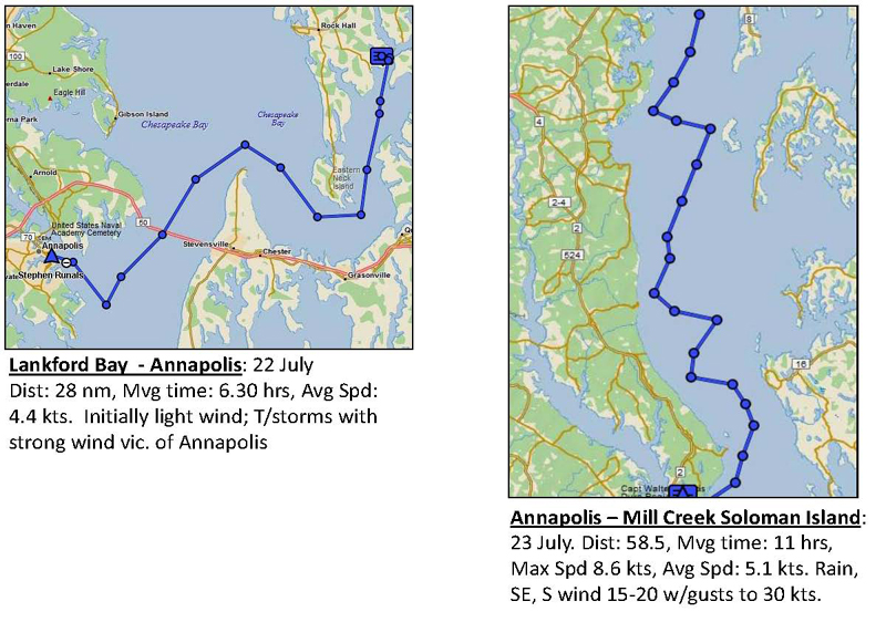
Day 4/5 – Mill Creek, Solomons Island to Cape Charles: As we pass Point Lookout on the north side of the Potomac River, the rain lessens but winds remain strong as we cross what can be a very challenging stretch of water. Night falls as we close on the Smith Pt Light. Once past the Light and the traffic separation zone located there, the wind backs to the ENE and drops into the high teens allowing us to sail a more direct course toward Cape Charles. We deploy the genoa and give the motor a well desired rest. This welcome break is short lived; the wind clocks back to the SE and gusts to 30+ knots. Getting the genoa furled provides a good workout. As the night progresses the winds back a little to the east and the sky clears between rain showers revealing an almost full moon. A beautiful site considering that we are seeing more of the moon than the sun during the last few days. By 0600 hours and the change of the watch, we approach the
entrance to Cape Charles and take the opportunity to do a little sailing
through an anchorage which holds some 17 ocean going ships.
The wind has dropped to 8-14 knots and we have a great sail among these
huge ships. We practice heaving to
and forereaching before heading to the Old Plantation Flats Light and
following the narrow but well-marked channel into Cape Charles harbor.
The crew gets to see and use the two ranges or transits that help to
guide us into this small but growing Bay-side town.
Once the boat is secured, we take showers and head into town for a
much-desired breakfast. The crew
all did well on this challenging overnight passage and we take some time to
stretch our legs and catch up on some sleep before starting our planning for
tomorrow’s adventure. Dinner
ashore at the Hook-U-Up provides an excellent way to end the day. Day 6/7 – Cape Charles, Offshore to Delaware Bay and
River to Summit North in the C&D Canal: By late afternoon the wind fills in from the south so we rig the whisker pole and have a fine downwind run. For most of the crew this is the first time they have sailed wing-an-wing with a poled out genoa. All see its advantage in these conditions. Before dark the wind drops, so we put in a precautionary reef in the main and motor sail north under clear skies and a full moon. As we rotate watches we practice “dipping the light” and determining “distance off” by doubling the angle off the bow and tracking our position by keeping a DR plot. All gain confidence in the accuracy of keeping a DR position when the DR plot is very close to a GPS fix. Little traffic, cool temps and a bright moonlit sky make for a great sail. Our goal is to reach the entrance to the Delaware Bay in time to take advantage of at least some of the flood tide. Just after sunrise we encounter a thick fog that drops the visibility to less than a quarter-mile. Ryan monitors the AIS and radar while Etta and the Captain steer and keep watch. Without warning a fast moving sport fishing boat crosses close ahead of us, appearing and disappearing without a sound or any indication of its presence on AIS or radar. The fog clears shortly after and we make our entrance into the Bay at the tail end of the flood which carries us north for several hours. We work our way up the Bay in light winds for most of the day clearing passage information with ships, tugs and recreational vessels by VHF and working on running fixes. It’s a little strange having the sun out. By late afternoon we are getting close to our turn west into the entrance to the C&D Canal just past the Salem Nuclear Power Plant. Showers are seen in the distance and warnings of strong T-Storms come over the VHF. We drop all sails and motor into what quickly becomes increasingly heavy rain and wind. We notify an approaching northbound tug of our location. He informs us he is towing a large empty barge that because of the strong winds is being blown across the channel. We move well outside the channel to give him room and track a large ship headed south. In the strong winds and rain the visibility is less than 1/8th mile. The Captain tracks the storm and approach of the two ships on the radar and AIS and the Sirius weather program, and gives steering directions to Tom who is now on the helm. At one point, the strong winds, gusting to 34+ knots, and now strong ebbing current push us toward shallow water and a line of crab pot floats. Adrian spots what looks like a breakwater in the distance. Quick action by Tom and Adrian gets us out of the shallow water but still clear of the channel and the very close passing of the tug and ship. Both vessels are soon clear and the rain lets up, and the high adventure of the past 15 minutes is over. We proceed to the entrance of the C&D Canal,
carefully adjusting course and speed to account for the current and are soon on
our way down this unique waterway. As
we approach the entrance to Summit North Marina, the radio again warns of
strong T-Storms, and the clouds darken and lightening flashes strike close by.
As we approach our slip, we are “helped” by strong winds and driving
rain that makes docking another challenge on this long day.
Once secured, we catch our breath, take showers and have dinner in a very
crowded Grain H2O restaurant that is having a full moon party.
Sleep comes quickly after this very full day.
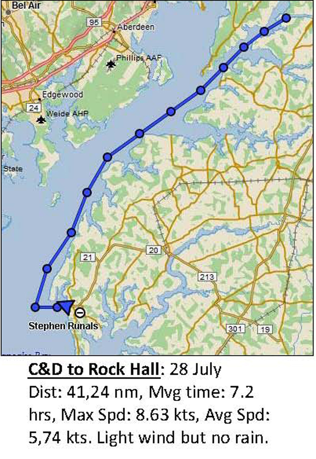
Day 8 – Summit North in the C&D Canal to Haven
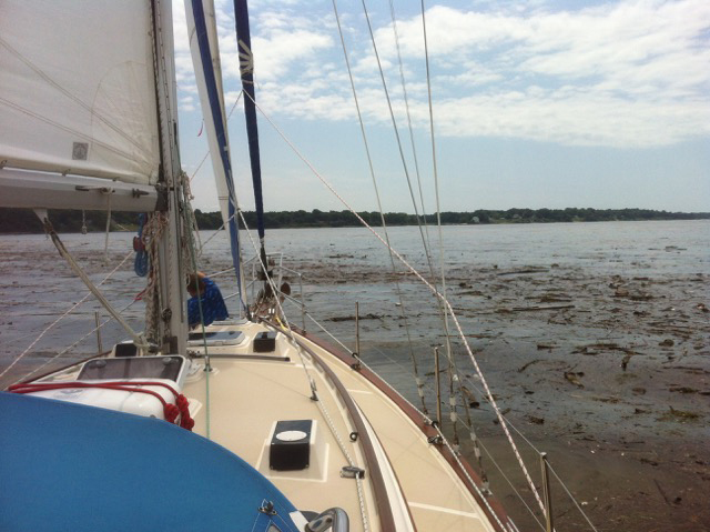
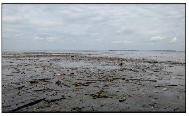
Harbor, Rock Hall The heavy rains of the last several days throughout the Chesapeake Bay watershed has resulted in the Corps of Engineers opening the gates on the Susquehanna River dams. This has resulted in a tremendous amount of debris coming down the Bay. Shortly after reentering the C&D Canal we begin to see areas of tree limbs, brush, grass and other floating items. The further south we go the more we find, requiring us to post a lookout on the foredeck and carefully working our way through what becomes quite large debris fields. Initially we have to stem a flood current but once past Turkey Point and into the main Chesapeake Bay, we get an assist from an ebb current assisted by the released water from the dams to the north. We motor sail south in light winds keeping a careful eye on
the logs, tires, trash and other debris that now cover large areas of the Bay.
By early afternoon we are off the approach to Swan Creek and Rock
Hall. Tom takes us carefully
across the Swan Creek Bar and into Gratitude Marina where we
refuel and pumpout before proceeding to our slip at Heaven Harbor.
We find it a little strange to have gone the day without any rain, but no
one seems to mind this pleasant change.
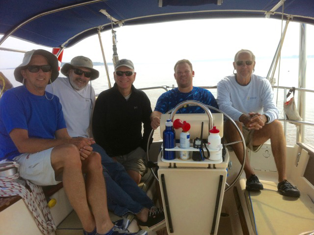
Before departing, we clean the boat and conduct a course review. It’s been a good trip with some unique challenges. The crew has done well. All have learned much, not only improving individual sailing skills but about themselves. All look forward to the opportunity to apply newly developed skills in their own sailing and look forward to sailing together again.
Well done, fellow mariners. Tom and I salute you – with thanks and appreciation. Fair Winds to each. Captain Steve Runals
|
|||||||||||||||||||||||||||||||||||||||||||
Web site design by F. Hayden Designs, Inc.