|
Home
Purpose
Schedule of Courses
Course Descriptions
Course Prerequisites
School Yachts
ASA Certification
Registration Info
Our Location
Our People
Contact Us
School Store
Cruise
Reports
Photo Album

|
|
~ A Cut Above ~ |
|
| Course: |
Advanced Coastal Cruising; DELMARVA Circumnavigation |
| Date: |
July 8-15, 2017 |
| Vessel: |
S/V NAVIGATOR, IP40
|
| Students: |
David Goslin, Steve Hart, Don Standley,
Zoltan Sternovsky |
| Captain |
H Jochen Hoffmann |
Pre-departure
Preparation
I arrive Wednesday, early on Friday, July 7 to meet Tom
Tursi of the Maryland School to check out new, user-friendly electronics
installed on S/V NAVIGATOR and prepare
the ship for our voyage. My experienced student crew arrives during the
afternoon, and we finish meal planning plus initial introduction to systems
below. Over dinner at Bay Wolf restaurant, we get to know one another and
pre-view our upcoming cruise. In fact, our “pre-view” had begun earlier with
pre-planning assignments for each focusing on key components of an offshore
passage: using resources to achieve an efficient departure, safe ocean transit,
and successful landfall. To this end, students had looked up charted hazards,
tides at key points, bridge elevations and navigation lights protruding down
from bridge girders, harbors-of-refuge, USCG
Light List (LL) entries for crucial departure and landfall waypoints, etc.
Weather analysis would come later.
Saturday, July 8,
2017, Day 1 - Lankford Creek to Swan
Creek, west of Rock Hall
In the context of preparing for departure – i.e., not
simply casting off, but being away from familiar waters and boat supply/repair
facilities or, in our case, upon the open sea – it makes sense at this
advanced course level to view our first 3 days as a coherent unit. We are
spending this training time to acquire skill sets prudent mariners need to be
ready to face open water. We’ll soon see what is involved before we can
confidently cross the COLREGS line, that line on charts separating inland from
open, international waters.
In our case, we start day 1 after a simple breakfast,
inspecting personal gear, lines, sails, and winches above deck, and systems and
equipment below, including safety equipment. Next, we break out charts and the
essential NOAA-Chart No. 1, plus
navigation tools and a sample navigation plan work sheet. We use all to develop
our first navigation plan from Lankford Bay down the Chester River and into Swan
Creek off Rock Hall on the Bay-side. While that is underway, some crewmembers
shop for provisions which were stowed expeditiously. Mid-afternoon, after
checking weather reports and topping off water, we navigate per plan to our
first anchorage at Swan Creek. We find it already crowded with pleasure boats.
Feeling uncomfortable with our first anchor spot, we raise the gear, find a
slightly less crowded location, and enjoy a delicious dinner in the cockpit
produced by our “Master Chef” Steve.
Day 2 – Rock Hall
to Summit North Marina, Chesapeake and Delaware Canal
We are now building on existing skills in earnest. We
depart at 0730, perform engine and Man-Overboard (MOB) maneuvers, and, with a
light breeze on the stern at S 5-8 knots, we set a full main with preventer to
get at least a little lift on our run northward. The legs up Chesapeake and
tomorrow down Delaware Bays serve for all to become thoroughly familiar with the
boat and watch routines needed on a long voyage. Initially, we establish a
rotating one-hour schedule of crew roles and duties, namely: navigator, lookout,
helm, deck hand, and idler/assistant navigator, in order to review and reinforce
essential skills. The Captain introduces the chart plotter as the first of
several electronic navigation tools on board. Don is quickly becoming “a
natural” here. Discussing expected traffic, the Captain reminds all that, as
sailboat operators, we need to realize that we are more often than not
distracted by on-board activities and also short-handed since trained crew is
hard to come by. The Captain outlines the role of “Skipper-of-the-Day” from
noon to noon, which will further sharpen the crew’s focus as they learn to be
in charge underway. The crew calls ahead to Summit North Marina to arrange for a
slip and we dock in ample time to have dinner ashore, shower, and develop the
next day’s navigation plan.
Day 3 - Summit North
Marina to offshore via Delaware River and Bay
“Tidal Gate” consideration, i.e., leaving on the tide,
has been a determining factor for mariners for centuries. Alas, with our
desirable ebb tide starting as late as 1258 at Reedy Point at the Canal exit one
hour away, we’d reach the ocean near midnight. Not a desirable choice for
those venturing offshore for the first time. We decide to make our Canal exit at
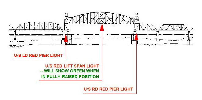
0900, bucking the tide as best we can. We clear the Conrail lift bridge, which
happens to be in a fully raised elevation and note its all-important nav lights
(see diagram).
MINIMUM
LIGHTING FOR VERTICAL LIFT BRIDGES:
(As Viewed from Upstream)
|

|
Click to enlarge |
Our nav plan down river includes a harbor-of-refuge
landfall detour through the narrow Reedy Island Dike entry. Here we practice
deployment of our MOB system (secured to the ship by a lanyard) and its
retrieval. As we motor down-river, we pay closest attention to our heading to
avoid straying into the busy shipping channel. Zoltan and David who had both
just finished their ASA105 Coastal Navigation exam are most helpful in this
effort. Underway, we perfect the skills of taking bearing fixes on the Salem
Nuclear Power Plant to find our position and check course headings. Steve is the
first to be “spot-on.” We review plotting in True vs. Magnetic directions,
ASA106 text topics and discuss what to expect once offshore during the 4-hour
watch periods. The Captain establishes Standing Orders and Night Order to ensure
that all know to call on the Captain if the wind shifts or increases by certain
values, a ship comes within a certain radius, etc. He then takes the wheel so
that the crew can rest for a couple of hours.
Once out of the River, we had set all sails. Still, the
counter current makes for slow going. By the time we pass the COLREGS
Demarcation Line, it is full dark. Our navigators had picked as departure point
from the Delaware Bay the NW perimeter buoy G “5” Fl G 2.5 s Gong of the
charted Pilot Area which lies just E of Hen and Chickens Shoal. We are all set
to head into the Atlantic, course 167º True. Alas, the best course our watch
can hold in prevailing conditions is 155º per ship’s compass. We observe a
line of commercial vessels in the Traffic Separation Zone the proximity of which
sets off our AIS alarm, but hey pass safely. Winds stay light and we motor sail
through an otherwise uneventful night.
Day 4 - Ocean to
Landfall at Cape Charles Harbor, Chesapeake Bay Entrance
Throughout the new day, our navigators pursue DR (Deduced
Reckoning) navigation in earnest. Tabular log entries per the School’s
training book and hourly boat and weather checks are part of the routine. David
spots a huge sea turtle close aboard and others see the first of several
dolphins. The wind has died down and because of our late start yesterday
morning, we are still miles from the Chesapeake Bay Entrance. But it’s none
too soon to discuss safe landfall in full dark. For our landfall preparation, we
look at the Light List for the set of
buoys marking the North Channel through Fishermans Island Bridge (shown on Chart
12221 as CHESAPEAKE BAY BRIDGE TUNNEL TRESLE D). The crew charts a course to our
landfall buoy: R “2N” Fl R 4s, SW of Nautilus Shoal at 37º19.150'N; 075º54.22'W.
We discuss our vessel’s “air draft” of52 feet) and conclude that Navigator’s
mast plus antenna can safely pass under Fishermans Island Bridge with its
charted vertical clearance of 75feet. As we get closer and eyes are trained to
locate the Fl 4s light of our entrance buoy, Don, as navigator, is earning his
stripes. He calls out distance to the buoy, but we see nothing in the dark. When
he shouts: “You are there,” our spotlight illuminates the buoy, its 4s light
extinguished. Lesson learned. From R N “12”, we steer toward the lat/long of
the charted Horn marking the E side of the main channel at 37º05.3'N by 75º59.2'W
(LL # 21395) to
achieve safe bridge passage. Once the green, main channel lights protruding
downward from the two bridge lanes line up (see diagram), we cross under them.
MINIMUM FIXED
BRIDGE LIGHTING (MAIN CHANNEL ONLY)
(As Viewed from Upstream)
|
|
Click to enlarge |
Landfall in Cape Charles Harbour proves more challenging
than expected. First, the range lights of Cherrystone Channels A and B are
impossible to make out against light scatter ashore. But once again our
navigators are coming through. Second, Cape Charles Harbour has vastly expanded
facilities with a new mega yacht repair yard being built. To make piloting even
more challenging, our very own marina docks are unlit requiring us to inch
forward, find an empty T-head dock and, finally, make fast. It’s 0130 in the
morning of day 5. We ore tired but mighty pleased with our success.
Day 5 and 6 - Cape
Charles Harbor to Points North
After breakfast at the venerable Cape Charles Coffee House
(its décor of the early 1900s still evoking the haberdashery it once housed) we
clean the boat. A light lunch, a siesta, and working out the navigation plan
comes next. The Captain calls the U.S. Coast Guard and reports that the light of
the North Channel approach buoy is extinguished. The crew has opted to sail
through the night to gain additional experience and to avoid much of the hot,
humid July air and sun. At 1600 we drop lines, pump out at the fuel dock,
and—once we have cleared the Cherrystone Channels--set a course of 355ºpsc to
eventually clear Smith Point Light and the mouth of the Potomac during the
night. With winds forecast SSW 10-12 knots on our port quarter for the night, we
set a full main and genoa. While we maintain the same watch schedule with the
Captain on call through the night, the Captain takes the wheel to 2100 and again
at 0600 to give the crew extra rest. The wind holds as predicted and we have a
delightful night sail up the Bay, occasional traffic notwithstanding. At 1230,
close to Annapolis, we hail the Harbor Master who has a slip for us. Sadly, one
of our shipmates has received a call that his elderly, ailing father has taken a
turn for the worst and he needs to leave to be at his father’s side. After
showers ashore, students take the ASA106 test, which all pass, and all sit down
to a relaxed dinner afterward.
Day 7 – Severn
River to Chester River
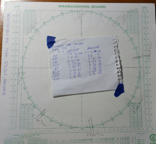
This morning we all engage in an exciting navigational
exercise: Setting up a Sun Compass as the first step to creating a deviation
table for NAVIGATOR. We motor to protected Whitehall Bay where, at
David’s request, we do one more anchoring exercise. At this point we set up
our instrument and Maneuvering Board at the bow’s midship line, raise the
anchor and have Steve’s steady hand at wheel steer successive courses at 45ºpsc
intervals. David and the Captain draw sun shadow lines on the Maneuvering Board,
while Zoltan, with the exactness of the scientist that he is, records courses
steered and time values for the azimuth entries down to the second.
|
|
Click to enlarge |
With thunderheads building and weather warnings coming in
over the VHF, we tie up at Cantler’s Restaurant in Mill Creek, have a meal and
cast off again at 2015 when the cold front has finally passed to the east of us.
We continue to Queenstown Creek where, at 1130, we perform a night-time
anchoring exercise and call it a day.
Day 8, Queenstown to
Lankford Bay Marina,
Our final day and leg back to our marina is uneventful.
Sailing the Chester River, now on a reciprocal course, shows that navigating has
become almost second nature to this seasoned crew. Of course, close out chores
– pumping out, fueling, docking, cleaning – are part of cruising, too. That
done, we bid each other a fond farewell.
Well done, my friends. Your Captain salutes you.
Fair Winds to you, always.
Captain H. Jochen Hoffmann
On board S/V
NAVIGATOR
July 15, 2017
Rock Hall, Maryland

|