|
|
2016 DELMARVA Reports |
Home
|
Pre-departure
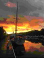
Preparation: Dinner at the Waterman’s
Crab House provides an opportunity to continue getting to know each other
that we began earlier in the month during a webinar in which we discussed
individual class goals and sailing backgrounds as well as an overview of the
course. Stowing refrigerated food early is a good way to ensure it is
well cooled with the help of shore power rather than battery power before
casting off; so after dinner, we provision for our trip.
Once our supplies are stored, we check out individual safety equipment,
go over interior boat systems and assign pre departure duties.
An early bedtime is a welcomed end to the day. Saturday: Day 1
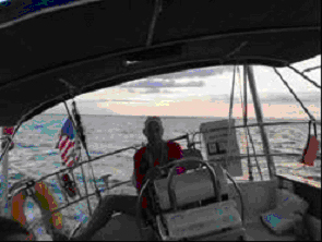
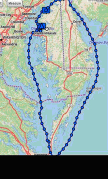
- Lankford Creek to Swan Creek, Rock Hall: After reviewing individual pre departure tasks, we take the next several hours to complete assigned tasks. Wrenford, our navigator for the day, develops our first navigation plan from Lankford Creek down the Chester River to Swan Creek off Rock Hall. After topping off water, we head down the Chester River to our anchorage at Swan Creek. Along our way we practice MOB under power; all have a chance at steering the boat; we practice raising and reefing our sails in the light wind and rigging the whisker pole while Wrenford tracks our progress by taking two bearing fixes and updating our arrival time. We arrive at our anchorage just beyond the mooring field in Swan Creek on schedule. The anchorage is crowed with several groups of rafted up boats giving us the opportunity to discuss the considerations that need to be taken into account when tying together multiple boats. We enjoy dinner and a fine sunset while discussing the day’s events. The weather forecast calls for a building wind, veering to the east so we ensure our anchor is properly set and can accommodate the change in direction. Anthony works out our navigation plan for the next day that takes into account the tide on the Swan Creek Bar, the strong current in the C & D Canal and a desired arrival time at the Summit North Marina before dark and before the fuel and pump-out dock closes. This planning leads us to determine that unless we depart by 0100 tomorrow, we will never make the 50 nm trip to Summit North without encountering a strong ebb current in the C & D Canal. We choose instead to depart at
high tide on the Swan Creek Bar and work our way north to an anchorage in
the Sassafras River to put us close to the entrance of the Canal.
Our quiet anchorage is a little less so tonight.
It seems that Rock Hall is “party city” and we have free
admission. By 2100 hours things quiet down, and despite the forecast, a
light wind makes for quiet, cool night and welcomed rest. Day 2 - Rock Hall to
Sassafras River: Once the anchor is secured, we carefully exit the Swan Creek Channel. We arrive at the entrance buoy to cross the Swan Creek Bar with several other boats; all make the crossing to deeper water without incident. Once across, we take the opportunity practice all points of sail and tacking and jibing to get all crew familiar with the commands and actions required to execute each task. The wind remains with us as we reach up the Bay practicing taking two bearing fixes and monitoring traffic. All get a feel for the use of the AIS (Automatic Identification System) as a steady stream of pleasure boats pass going north and south. We rotate steering the boat and taking fixes to track our progress northward. Once past Pooles Island, we practice MOB under sail and all have a chance to see the several sets of transits or range lights that will become common sites as our trip continues. Early afternoon finds the wind dying so we motor sail against a building ebb current to an anchorage on the south side of the Sassafras River. Along the way Tom, Kevin and the Captain change out the deck wash down pump with a new spare. Having spares and being able to effect minor repairs is an essential part of cruising. The forecast calls for rain
but we enjoy a quiet night during which Tom, our navigator for tomorrow, works
out our timing to take advantage of a morning flood current to get us to the Summit
North Marina located in the middle to the C&D Canal.
Day 3 -
Chesapeake and Delaware Canal, Summit North Marina: By 1130 when we contact the
marina, the rain has become a light shower giving us a welcome break. After refueling and pumping out, we secure the boat, do a
quick cleaning of the inside and take welcome, warm showers. Kevin and Richard,
who will share the navigator role, as we head down the Delaware River and
Bay and then offshore along the DELMARVA coast, determine that an
early departure is required to allow us to maximize the ebb current to get us
down to the mouth of the Bay before the current changes. We complete our pre departure checks, top off water, review
watch-standing procedures and check personal equipment before enjoying a
beautiful sunset, an excellent pizza/salad dinner and early bedtime.
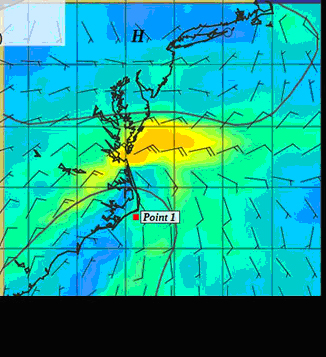
Before turning in, the Captain contacts Tom Tursi for a weather check. By now Tropical Storm Julia is no longer a threat and the forecast calls for 10 -15 knot NE/E winds. We do discuss a potential low pressure area shown in the Weather GRIB files (computer model forecast, not analyzed by a meteorologist) developing off Cape Hatters and moving slowly toward our entrance into the Chesapeake Bay. The threat seems manageable so we confirm an early departure for tomorrow.
Day 4 - Summit North Marina
to offshore via Delaware River and Bay: We spend the day resting,
rotating the watch, tracking our progress south and monitoring passing ships.
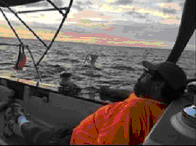
By 1700 we round Cape Henlopen in a NE 10-15 knot wind.
As we turn SW it’s time to set the whisker pole and sail wing -& -
wing but before setting the pole, we tuck in a mainsail reef.
Reducing sail is prudent as night falls and the ability to see
approaching squalls is reduced. This sail combination makes for great sailing
Kevin makes a great evening meal that gets us ready for a long night at
sea. The captain reviews the “Standing and Night Orders” with
the crew to ensure that all know when to call on him if the wind shifts or
increases, a ship will pass within
close proximity, and course to steer guidance.
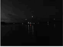
Despite the building seas, the boat and watch crew handle the conditions
well. We have a chance see a star
filled sky till late in the evening when the stars blink out as overcast turns
to rain and the wind increases.
Day 5 - Offshore to the
Chesapeake Bay Entrance and Cape Charles Harbor: We cross into the Bay
just after it begins to get light. In
the steadily growing light, we stay close to the coast to get a break from the
still strong wind and high waves we motor sail north, passing first the concrete
ships at Kiptopeke State Park and then the Old Plantation Light at
the entrance to the channel leading into Cape Charles. The rain gives us
a break allowing us another chance to see first-hand the benefit of using the
two ranges or transits marking the center of the channel into the harbor.
We tie up at the Cape Charles Town Docks by 1130, do a quick
cleanup of the boat so first the heater and then the A/C can start to dry out
our damp interior. It has been a
fast passage, 31 hrs to cover the 197 nms from Summit North Marina; at an
average speed of 6.35 knots. All have done well. For
most of the crew this was their first time sailing at night and in the ocean:
the 30 + knot winds, 5 to6 ft waves and rain, at times heavy, were a good
“baptism under fire.” After securing the boat we
head up to the marina restaurant followed by showers, rest and a little
exploring before an early dinner at Kelly’s Tavern. Before turning in for an early bedtime we wander the streets
of this old town. The lack of
traffic seems to indicate we are not the only ones interested in going to bed.
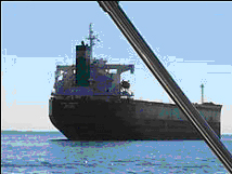
Day 6/7 – Cape Charles
Harbor to Lankford Bay Marina: The evening forecast is for NE 5-10 winds and clearing skies. We reach the mouth of the Potomac River by 2200 hrs as the winds dies away to a light breeze; the skies have cleared and we motor sail north under a star filled sky. As be cross the Potomac, commercial traffic starts to pick up. AIS does its job, providing early warning of the approaching traffic that will become 7 ships or tugs pushing/pulling barges passing us between 2200 and 0700 hrs. In between this flow of traffic we execute our MOB drill. While we quickly recover our lighted MOB float, all see the importance of staying on the boat and the difficulty of recovering an MOB in the wind and wave conditions we had the day before when we were entering the Bay. The ones most impacted by the MOB drill are the off watch crews that were asleep and called on deck for the drill. As the sun is making its
appearance we have a convergence of two tugs with barges and a tanker.
We all safely pass in close proximity having monitored VHF 13 for passing
instructions. The forecast for the
day and tomorrow is calling for 5 knot winds so we make the decision to continue
on past Annapolis to Lankford Bay.
It’s a long motor sail home under clear skies and flat seas.
We arrive back at the marina in time to refuel, pump out and tie up in
our slip by 1600. It has taken us almost 27 hrs to travel the 143 miles from Cape
Charles, a slow but steady trip that has reinforced the importance of
keeping an alert watch, monitoring traffic and adjusting our sails to the wind
and sea conditions.
Our ship has taken good care
of us, so before taking showers and a welcomed dinner ashore, we clean the boat
inside and out. Dinner provides a
great opportunity to discuss impressions and insights gained from our time on
the water. All were impressed by
the way S/V Navigator
handled wind and waves and how their individual skills improved during the trip.
Most importantly, each has gain confidence in their ability to handle a
wide range of conditions that are part of coastal cruising.
It’s been a great trip. Now
only major task remains ……“Test.”
Day 8 - The
“Test”: Well done, fellow mariners. I
salute you – with thanks and appreciation.
Fair Winds to each. Captain Steve Runals
|


Web site design by F. Hayden Designs, Inc.