|
|
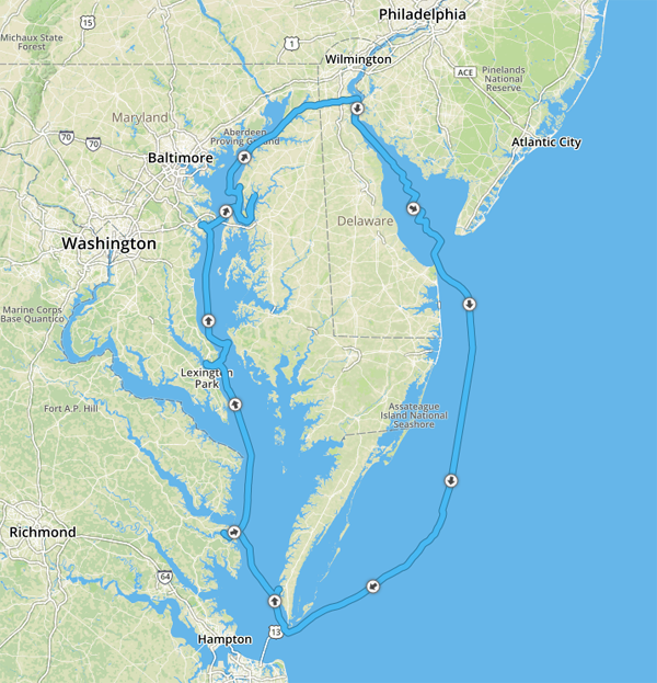
2016 DELMARVA Reports |
Home
|
Pre-departure
Preparation I arrive Wednesday, June 29 to meet Tom Tursi of the Maryland School to check out new electronics installed on S/V NAVIGATOR and prepare the ship for our voyage.. My highly experienced student crew arrives during the
afternoon of July 1, and we finish meal planning plus initial introduction to
systems below. Over dinner at Bay Wolf restaurant, we get to know one another
and preview our upcoming cruise. In fact, our preview had begun weeks earlier
with an online meeting and preplanning assignments focusing on key components of
an offshore passage: consulting resources to achieve an efficient departure,
safe transit, and successful landfall. To this end, students had looked up
charted hazards, tides at key points, bridge elevations and navigation lights
protruding down from bridge girders, harbors-of-refuge, USCG Light List entries for crucial departure and landfall
waypoints, etc. Weather analysis would come later. Saturday, July 2,
2016, Day 1 - Lankford Creek to Swan
Creek, Rock Hall In our case, we start day 1, after a simple breakfast,
inspecting personal gear, lines, sails, and winches above deck, and systems and
equipment below, including safety equipment. Next, we break out charts and the
essential NOAA-Chart No. 1, plus
navigation tools and a sample
navigation plan work sheet. We use all to develop our first nav plan from
Lankford Bay down the Chester River and into Swan Creek off Rock Hall on the Bay
side. Also, Andrew and the captain shop for provisions and stow these in
designated lockers so they can be easily accessed during the cruise.
Mid-afternoon, after checking weather reports and topping off water, we navigate
per plan to our first anchorage at Swan Creek. We find it already crowded with
pleasure boats. Feeling uncomfortable with our first anchor spot, we raise the
gear, find a slightly less crowded location, and enjoy a simple dinner in the
cockpit. Day 2 – Rock Hall
to Summit North Marina, Chesapeake and Delaware Canal The crew calls ahead to Summit North Marina to arrange for a slip and we dock in ample time to have dinner ashore, shower, and develop the next day’s navigation plan.
Day 3 - Summit North
Marina to offshore via Delaware River and Bay MINIMUM
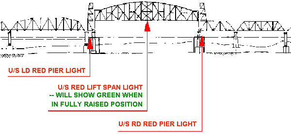
LIGHTING FOR VERTICAL LIFT BRIDGES: (As Viewed From Upstream)
At the potentially dangerous exit from the C&D Canal
(swift currents, shoal at exit), we use compass bearings to nearby Nav Aids
picked by student crew to keep us safely off the breakwaters which can be
submerged at high tide. Again as part of pre-planning, Andrew had listed tides
and currents for local waters and Bob had looked up local magnetic disturbances
that can affect the ship’s compass heading. Pete had found the charted, narrow
opening through the long Reedy Island Dyke, through which we actually steer to
simulate a bail-out landfall in case of a sudden gale. South winds at 10-15 knots won’t allow us to sail in the
shallow waters of the River’s auxiliary shipping lanes. So we motor down river
and perfect the skills of taking bearing fixes on the Salem Nuclear Power Plant
to find our position and check course headings. We review ASA106 text topics and
also discuss what to expect once offshore with the four hour watch schedules now
set as follows: Watch No I from 0000 to 0400 hours is Bob and Adrian; No II from
0400 to 0800 hours is Rene’ and Andrew; No III from 0800 to 1200 hours is
Captain Jochen and Pete. As the River widens into Delaware Bay, we raise
mainsail and genoa and, mindful of the many commercial ships, we tack toward
open waters, still 25 NM away. The Captain establishes Standing Orders and Night
Order to ensure that all know to call on the captain if the wind shifts or
increases by certain values, a ship comes within a certain radius, etc. He then
takes the wheel so that the crew can rest for a couple of hours. At sunset, we have a simple meal in the cockpit and discuss
tonight’s weather report: S 10-15 knots on the nose, seas 2-3 feet, patchy
fog, and visibility 1-3 NM. Since a weak front is to pass through, we use the
waning light to put one reef into the mainsail. Our navigators had picked the
departure point from the Delaware Bay as the NW perimeter buoy G “5” Fl G
2.5 s Gong of the charted Pilot Area which lies just E of Hen and Chickens
Shoal. Voila, we are set to head into the Atlantic, course 167º True. Alas, the
best course our Watch No III can hold in prevailing conditions is 155º per
ship’s compass (psc). At 2230 we finally pass the COLREGS line as Bob spots a
fast boat heading our way from Lewes, DE. Its distinctive navigation lights
bring to mind this helpful rhyme: “white over red, Pilot ahead.” Indeed,
this vessel passes astern to rendezvous with a huge container ship waiting
inside the designated Pilot Area. As the next watch (Bob and Adrian) takes over
from the Captain and Pete, we observe a long line of commercial vessels in the
Traffic Separation Zone the proximity of which sets off our AIS alarm. Day 4 - Offshore to
Cape Charles Harbor, Chesapeake Bay Entrance Throughout the day, our navigators pursue DR (Deduced
Reckoning) navigation in earnest. During hourly boat and weather checks, they
find that our manual bilge pump is not functioning properly. So we return to
using the electric bilge pump manually and count seconds until the bilge is dry.
Bob sees the first of several dolphins and turtles during our trip. Since the
sea is now flat with no wind, Andrew and Pete who had already taken the ASA107
Celestial Navigation class, break out their sextants and start taking sun shots. At 1610 at 37º22.875'N; 075º15.384'W, we are still miles
from the Chesapeake Bay Entrance, but it’s none too soon to discuss safe
landfall. For our landfall preparation, we check the Light List for the buoys marking the North Channel through
Fishermans Island Bridge (shown on Chart 12221 as CHESAPEAKE BAY BRIDGE TUNNEL
TRESLE D} and Andrew charts an initial course of 215º psc to buoy R “2N” Fl
R 4s, S of Nautilus Shoal at 37º19.150'N; 075º54.22'W. We discuss our
vessel’s mast height which is 52 feet and conclude that Navigator’s mast plus antenna could safely transit
under Fishermans Island Bridge with its charted vertical clearance of 75 feet.
As we get closer, we motor sail along the light’s latitude line of 37º19.150'N
and watch the numbers on our hand-held GPS climb slowly toward 075º54.22'W.
Soon Rene’, upon looking at the chart and considering Navigator’s draft, reasons that flat seas and the
absence of swells and crab pots should allow us to make a “dog leg” across
decreasing but sufficient depth to enter the Channel further north. All agree,
and with lookouts shining flashlights on either side (it’s now full dark) we
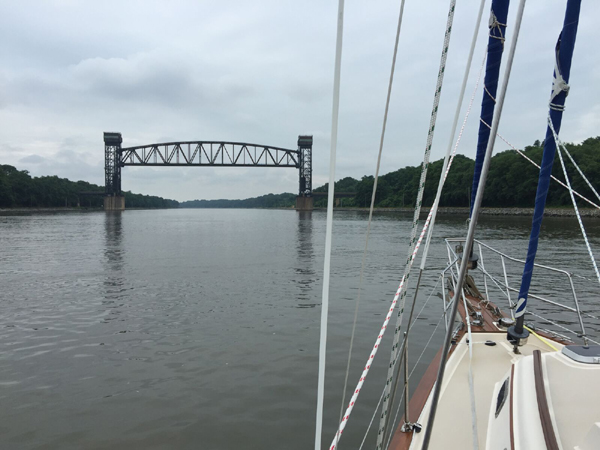
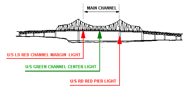
pick out the channel buoys as the bridge ahead looms larger and larger. With Bob at the wheel steering expertly into the flood current, the captain uses the drive-by approach along multiple bridge piers with red lights until the green, main channel lights protruding downward from two bridge lanes line up (see diagram). Now, rudder hard left into the north-rushing current, and we are through. Alternatively, in fog, we would have (per Light List) steered directly from the last channel buoy toward the charted Horn (Light List # 21395) to achieve safe bridge passage. MINIMUM FIXED
BRIDGE LIGHTING (MAIN CHANNEL ONLY) (As Viewed From Upstream)
It is now past 2200 and with the current still on our
stern, plus one huge Menhaden trawler barreling down on and past us, we rush
toward Cape Charles Harbor. Pete and Andrew, eyes glued to the chart plotter,
delight in giving us time/speed/distance to marks en route down to the minute.
The captain had called ahead indicating to the dock master that we would tie up
at a T-head dock upon arrival. Again, with lookouts posted, we finally tied up
at 0030 - tired, but quite pleased with our achievement. Day 5 - Cape Charles
Harbor to Fishing Bay The crew decides to sail north during daylight hours. Yet,
to get some ASA106 night time operations into our experience bank, we depart at
1515 for Fishing Bay on the Piankatank River for a night-time arrival. As we
cast off, our navigators demonstrate their skill in close-quarter navigation
shown by their nav plan to keep us in the Cape Charles Channel and away from 4
ft shoals: 1507
R ”4”
Fl R 4s 0.3 NM At 2015 Andrew navigates us toward Fishing Bay as heavy
weather clouds loom ahead. With thunder and lightning almost upon us, we manage
to set two anchors off the bow just as the heavens open up. Sheltered under the
cockpit canvass, we watch lightning flashes light up the sky. Day 6 – Fishing
Bay to Solomon’s Island, Day 7 - Solomon’s
Island to Annapolis
We see summer pop-up clouds building in the west and Pete is applying his minute-by-minute time/speed/distance calculations to squall front tracking. “Twenty minutes to rain fall.” Down comes the pole and all sails – just in time before the tropical downpour cuts our visibility to zero. Navigation lights - already on – are supplemented by our fog signal every two minutes. Out navigators are monitoring radar and AIS while Adrian, Rene’ and Bob are lookouts fore and aft as we approach the Harbor channel. So familiar in more southerly latitudes or the Caribbean, this experience is new for some. Blue skies return just in time for us to pick up our mooring, shower ashore, and enjoy dinner at Pusser’s.
Day 8, Annapolis to
Lankford Bay Marina,
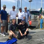
Well done, my friends. Your captain salutes you – with
thanks and appreciation. Fair Winds
to you, always. Captain H. Jochen Hoffmann
|
Web site design by F. Hayden Designs, Inc.