2015 DELMARVA Reports


Home

Purpose

Schedule of Courses

Course Descriptions

Course Prerequisites

School Yachts

ASA Certification

Registration Info

Our Location

Our People

Contact Us

School Store

Cruise Reports

Photo Album


Send Email to office@mdschool.com


ASA Award School.jpg (302694 bytes)


ASA Award Tursi.jpg (522201 bytes)


ASA_Award_Tucker.JPG (465335 bytes)


ASA_Award_Boccuti.jpg (440516 bytes)


~ A Cut Above ~

Course Advanced Coastal Cruising; DELMARVA Circumnavigation
Date September 19-26, 2015
Vessel IP40 S/V NAVIGATOR
Students:

Pete and Lauren Calabria, Greg Beyer, Vince Di Stefano,  Bert Olsen

Captain Steve Runals

Pre-departure Preparation:
I arrive Thursday, September 17 to begin preparation of The Maryland School’s offshore yacht S/V Navigator before the students arrive.  Tom Tursi has installed new equipment and understanding its use is high on my preparation checklist. 

The student crew arrives during the afternoon of September 18th. Based on an updated weather forecast, we finalize our cruising and meal plans.  Dinner at the Waterman’s Crab House provides an opportunity to continue getting to know each other that we began the month before in a webinar in which we discussed individual class goals and sailing backgrounds as well as an overview of the course.  After dinner we review course material, check out individual safety equipment, go over interior boat systems and assign predeparture duties.  
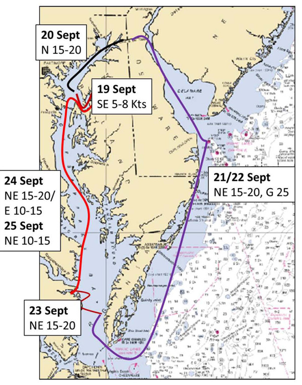
An early bedtime is a welcomed end to the day. 

Saturday: Day 1 - Lankford Creek to Swan Creek, Rock Hall:
After an early breakfast at Pasta Plus, we break into two groups – one to provision, a second to locate required safety equipment and begin working on pre-departure tasks. Stowing refrigerated food early is a good way to ensure it is well cooled with the help of shore power rather than battery power before casting off.  After stowing provisions we conduct an above deck orientation, checking standing and running rigging, sails, and winches, and safety equipment. Next, we review key chapters of the MDSchool’s Offshore Training book, the buoy system, navigation lights, break out charts, including the essential NOAA Chart No. 1, plus navigation tools and a simple navigation plan work sheet – all of which Lauren, our navigator for the day, uses to develop our first navigation plan from Lankford Creek down the Chester River to Swan Creek off Rock Hall. Each student is assigned responsibilities that prepare us for an early afternoon departure.  

After topping off fuel, water, and pumping out, we head down the Chester River to our anchorage at Swan Creek.  On our way we practice MOB under power; all have a chance at steering the boat and practice raising and reefing our sails in the light wind while Lauren tracks our progress by taking two bearing fixes and updating our arrival time.  We arrive at our anchorage just beyond the mooring field in Swan Creek.  We enjoy dinner and a fine sunset while discussing the day’s events.  The weather forecast calls for a building, veering wind to the north so we ensure our anchor is properly set and can accommodate the change in direction.  Pete works out our navigation plan for the next day that takes into account the tide in Swan Creek, the strong current in the C & D Canal and an arrival time at the Summit North Marina before dark and before the fuel and pump out dock closes.   These factors lead us to plan for an early departure time.  Our quiet anchorage is a little less so tonight.  It seems Rock Hall is “party city” and we have free admission.  By midnight things quiet down; a light wind makes for a quiet, cool night and a welcomed rest. 

Day 2 - Rock Hall to Summit North Marina, Chesapeake and Delaware Canal:
We are up before dawn for an early breakfast, preoperational checks and are ready to depart by 0600.  The forecast calls for 15-20 knot winds from the North and overcast skies.  We quietly raise and secure the anchor and carefully exit the Swan Creek Channel with crew on the bow with a strong light to identify unlighted buoys and crab pots.  For several it is an introduction to sailing at night and the importance of understanding how to use the navigation chart and indicated lights to safely navigate in the dark. We arrive at the entrance buoy to cross the Swan Creek Bar just as it gets light and make the crossing to deeper water without incident.  The forecast northerly wind has begun to fill in and with it building waves.  As we motor sail north with reefed main and staysail, all get a feel for the use of the AIS (Automatic Identification System) as a steady stream of commercial and pleasure boats pass going north and south. 

We rotate steering the boat and taking fixes to track our progress northward.  Our early departure time has us initially stemming a weak ebb current which by 0930 begins to slow and then flood north.  Pete monitors our progress so we arrive at the Old Town Point Wharf at slightly ahead of his desired time – max flood.  As we proceed into and along the channel, we are able to take advantage of strengthening flood current allowing us to arrive at Summit North Marina by 
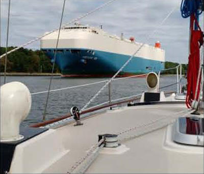
1500.  The high point of the transit occurs just after passing Welch Point.  We see a large car carrier approaching from Chesapeake City.  Vince, at the helm, takes us close to the starboard side of the channel as possible to give it all the room it needs to safely pass. This ship is huge, almost filling the narrowing channel.  Not often a ship that big passes so close to you.   

1.jpg (66909 bytes) Click picture to enlarge

Showers, an excellent dinner at the Aqua Sol Restaurant and navigation planning for our long passage down the Delaware Bay and along the coast to Norfolk close out this long day.  Bert develops a navigation plan to take maximum advantage of the ebb current in the Delaware River and Bay that should get us to the mouth of the Bay by late tomorrow afternoon.  To take maximum advantage of the current, we identify 0300 as a departure time from Summit North.  The weather forecast calls for NE winds of 10-15 knots building to 20 knots so we decide on 0400 as a better departure time.  Greg develops the navigation plan that will take us south along the DELMARVA coast.  The offshore forecast calls for continued NE winds of 15-20 knots with gusts to 25 knots.  We discuss options about delaying our departure but the forecast shows no improvement for the next several days.  Broad reaching in these conditions requires special attention to the sail plan so we rig a third reef in the mainsail and discuss running under staysail alone if conditions dictate.   We turn in early all tired but ready for tomorrow’s challenges. 

Day 3 - Summit North Marina to offshore via Delaware River and Bay:
Pete, skipper for the day, has us up, feed, preoperational checks completed, boat secured, water topped off and ready to go by 0400.  Before departing our slip we check to make sure the CONRAIL Railroad Bridge is open and traffic clear.  We have the canal almost all to ourselves and make our potentially dangerous exit from the C&D Canal (swift currents, shoal at exit) without incident. While in the Canal we are hailed by a sailboat that has just come up the Delaware Bay – cold and windy is their report for what lies ahead for us.  After safely clearing Reedy Point, we motor sail into a strong flood current and strengthening NE wind in the still dark morning.  As we near the Salem Nuclear Power Plant the sky begins to brighten and our navigation eases as we carefully track our progress south in the now ebbing current.  We shut down the motor and enjoy a fast beam reach south.   

2.jpg (54834 bytes) Click picture to enlarge

Once the current turns, we find ourselves moving at 8+ knots for several hours.  Tracking our progress by using fixes on lighthouses and other navigation aids is becoming second nature to all.    As we near the end of the Delaware Bay the current begins to flood and we see first-hand the effect of current running against the NE 15-20 knot wind.  Once clear of Cape Henlopen on the south side of Delaware Bay, we fall off to a broad reach surfing on 4-6 foot waves.  As night closes in we are well on our way along the DELMARVA coast under skies that change from clear and starry to overcast.  It’s great sailing with a deeply reefed main and genoa in fairly steady NE 15-20 knot winds.  The captain reviews the “Standing and Night Orders” with the crew to ensure that all know when to call on me if the wind shifts or increases by certain values, a ship comes within a certain radius, etc.  

Day 4 - Offshore Chesapeake Bay Entrance and Cape Charles Harbor:
The night passes uneventfully. We track our progress using shore lights and electronic fixes from the GPS.  By early morning, we have jibed and are headed for the North Channel fixed bridge and the entrance to the Chesapeake Bay.  The USCG has been reporting one of the lateral lights on the bridge as being out so we approach with caution.  Picking out the navigation buoy lights against the lighted background of the Bay Bridge is a challenge but well met. We cross into the Bay just as it begins to get light.  In the steadily growing daylight we motor sail north along the coast, passing first the concrete ships at Kiptopeke State Park and then the Old Plantation Light at the entrance to the channel leading into Cape Charles. We see first-hand the benefit of using the two ranges or transits marking the center of the channel into the harbor and are tied up at the Cape Charles Town Docks by 0900.  It has been a fast passage and all have done well.  For most of the crew this was their first time sailing at night and in the ocean - a good “baptism under fire.”  

Day 4 - Cape Charles Harbor: 
Before showers and a little rest, we have breakfast, clean the boat and work on several minor maintenance tasks before heading to the showers to clean up.  By 1400 we have eaten lunch and ready for a review of our passage and some group and individual study of ASA106 topics.  Vince, our navigator for the next leg of the trip up the Bay, begins work on our navigation plan. Cape Charles is an interesting little town well worth exploring.  By early evening we are ready for a good meal ashore, a walk to the beach and an early bedtime in anticipation of our trip up the Bay.  Before dropping off, Vince finishes the plan that will take us up to Annapolis against a still forecast NE 15-20 knot wind.  An agreed upon 1000 hours departure for the fuel dock allows all to catch up on sleep and a good breakfast before heading north in what should be a “sporty” ride up the Bay. All have no problem falling asleep.    

Day 5 – Cape Charles Harbor to Annapolis? – to Fishing Bay on the Piankatank River:
The day dawns clear and a little cooler with NE winds.  We are ready to depart for the fuel dock by 1000 but are delayed getting there by another boat – a young family with a 6 week old baby who need to pumpout before heading north the next day -  some things you just can’t anticipate.  By the time we depart the Cape Charles channel we have NE winds of 10-15 knots with gusts to 20 knots so our deeply reefed main and full genoa get us on our way.  We get a taste of the ship traffic we will encounter later on as we monitor the progress of several passing ships, coordinate passage with one and settle in for the beat north.  By mid-afternoon it becomes apparent that while the sailing is great, we are making slow progress along our course so we decide to make a detour and head into a protected anchorage off the Piankatank River.  This requires a modification to our navigation plan that Vince quickly accomplishes.  

Tacking north we are able to see the value of the cutter rig, using the staysail to help balance the helm.  
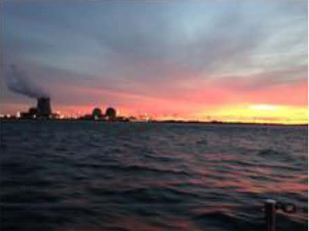
By late afternoon we are at the entrance to the Piankatank River.  Vince guides use around Stove Point Neck and into a very comfortable anchorage in Fishing Bay that protects us from the still strong NE wind. In the fading light we clear a jam in the anchor line, find that our genoa furling line is frayed and must be replaced, prepare dinner and watch a beautiful sunset.  It’s been a long but great sailing day in which we have learned the value of flexibility in cruising plans and the need for self-sufficiency. Before dropping off to a well-earned rest, Lauren reviews and modifies Vince’s navigation plan to account for our change and to minimize crossing the Potomac River in a counter wind and current situation.  The new plan calls for another early departure.   

Day 6/7 – Fishing Bay on the Piankatank River to Lankford Bay Marina:
Up early and ready to depart by 0600 hrs.  Despite the early hour, the four boats that have shared our secure anchorage are already underway.  All will be heading south using the strong NE winds to take them down the Bay.  We work our way out of the Piankatank motor sailing close hauled against a 15-20 knot wind and 3-4 foot waves.  Once clear of Stingray and Windmill Points, we fall off to a close reach taking advantage of the flood current.  By early afternoon we are crossing the broad Potomac River in dying winds.  The forecast calls for veering winds to the East at 10-15 knots which finally do fill in.  We shake out a reef and enjoy a great sail all the way up past Annapolis.  Along the way we encounter a steady increase in ship traffic.  AIS does its job, providing early warning of the approaching traffic that will become seven ships passing us between 2100 and 0500 hrs.  Several we coordinate passage with over VHF channel 13.  

As we approach Annapolis it looks like we might even be able to sail up under the Bay Bridge.  Vince and Greg on watch work their way as far as possible up into the wind to give the best options to pass under the bridge.  Just short of our target, a north bound car carrier calls and indicates he needs maximum room at the bridge.  We fall off, even heaving-to to allow him to safely transit the bridge but we now have to motor sail to clear the bridge.  Once safely clear of the bridge we conduct our man overboard drills.  In the early morning darkness all see how difficult it is to recover a MOB at night.  The ones most impacted are the off watch that was sound asleep and were called on deck for the drill.   The importance of staying connected to the boat is understood by all.   

The Captain and Bert have the watch.  We tack our way north to a position where we can make the Love Point Light.  It’s challenging distinguishing lights ashore from those for navigation. After safely making this key light and the surrounding crab pots, we fall off to a beam reach down the Chester River till, just east of the entrance to the Kent Narrows, where even short-tacking makes little progress against a backing NE wind.  Time to raise the crew and prepare to return to Lankford Bay Marina.  Sails are secured, dock lines readied and crew assignments made for docking at the pumpout, fuel dock and finally our slip.  Vince indicates he would like to pick up a mooring; so after refueling, we pick up a mooring in Long Cove.  Pete and Lauren, who have a lot of practice picking up moorings during their chartering, pass along their expertise as Vince easily executes this sometimes challenging maneuver.  Bert brings us back into our slip.  It’s good to be home. Our ship has taken good care of us so after a welcomed breakfast and before heading to well-earned showers and some rest and study, we give her deck a good wash down, clean the inside and store used equipment.  It’s been a great trip.  Now all that is left is the ……“Test.”   

3.jpg (220035 bytes)

Click picture to enlarge

Day 8 - The “Test”:
On our final day together we have breakfast on board, complete boat clean up and packing before we use S/V Navigator as a stage for a school picture.  Three classes - 13 students and three instructors crowd the stern of our trusty vessel for school group picture before we settle in for a chance to see just how much we have learned over the last seven days.  All take and pass the ASA106 test with flying colors.  I spend time with each student congratulating them on their accomplishments and discussing their strengths and areas for further development.  Each has done well; we have been a good crew.  All look forward to the opportunity to apply newly developed skills in their own sailing and look forward to sailing together again. 

Fellow mariners, I salute you for a job well done.  Fair Winds to each, always. 

Captain Steve Runals
On board S/V Navigator
September 27, 2015
Rock Hall, Maryland


© Copyright The Maryland School of Sailing & Seamanship, Inc., All rights reserved.
Web site design by F. Hayden Designs, Inc.