|
Home
Purpose
Schedule of Courses
Course Descriptions
Course Prerequisites
School Yachts
ASA Certification
Registration Info
Our Location
Our People
Contact Us
School Store
Cruise
Reports
Photo Album

|
|
~ A Cut Above ~ |
|
| Course: |
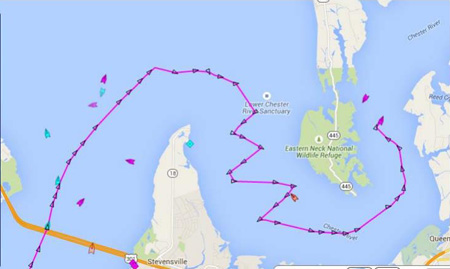
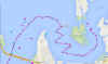
Advanced Coastal Cruising; DELMARVA Circumnavigation |
| Date: |
July 11-18, 2015 |
| Vessel: |
IP40 S/V NAVIGATOR
|
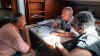
| Students: |
Janice Cannon, Jeffery Ivey,
Ramon Ayala and Hanno Klausmeier |
| Captain |
Steve Runals |
Pre-departure
Preparation:
I arrive Thurs, July 9 to help prepare the Maryland School’s newly acquired
Island Packet IP40 offshore yacht S/V FRINDSHIP to prepare
for this cruise. On Friday, before the students arrive, Tom Tursi, students from
an ongoing ASA 103 class, Frank and Suzanne Mummert and I christen the boat with
its new name S/V NAVIGATOR; a great way to prepare for our
offshore adventure.
The student crew arrives
during the afternoon of July 10. Based on an updated weather forecast, we
finalize our cruising and meal plans. Dinner
at the Waterman’s Crab House Restaurant allows us to continue getting to know
each other that we began the month before in a webinar in which we discussed
individual class goals and sailing backgrounds as well as an overview of the
course. Stowing refrigerated food early is essential to ensure that it is well
cooled with the help of shore power rather than battery power before casting
off, so after dinner we finish provisioning.
For some like Hanno who had arrived the day before from France and Jeff
who had driven down from MI, an early bedtime was a welcomed end to the day.
Saturday: Day 1
- Lankford Creek to Swan Creek, Rock Hall:
After breakfast at Pasta Plus, we begin inspecting personal gear, lines,
sails, and winches above deck, and systems and equipment below, including safety
equipment. Next, we review key chapters of the Offshore Training Cruises Prep
Guide (blue book) review the buoy system, navigation lights; break out charts,
including the essential NOAA-Chart No. 1, plus navigation
tools and a sample navigation plan work sheet – all of which Ramon, our
navigator for the day, uses to develop our first day’s navigation plan from
Lankford Bay Marina down the Chester River to Swan Creek off Rock Hall. Each
student is assigned responsibilities that prepare us for an early afternoon
departure.
After topping off potable
water tank, and pumping out the waste holding tank, we head down the Chester
River to our anchorage at Swan Creek. As
we pass the preferred channel buoy at the intersection of the Langford Creek and
Chester River we see the sails and long, narrow hulls of Log Canoes racing out
of Rock Hall Yacht Club. It’s a
real challenge to sail these unique Chesapeake Bay watercraft.
On our way we practice man overboard (MOB) recovery techniques under
power, and all have a chance at steering the boat, practice raising our sails in
the light wind, putting in and taking out a reef.
Ramon tracks our progress by taking two-bearing fixes and updating our
arrival time. We arrive at our
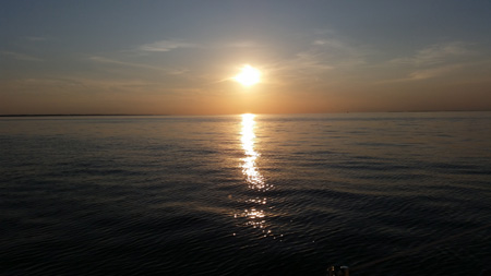
anchorage just beyond the mooring field in Swan Creek and prepare dinner. Ramon and Hanno go for a short swim. We enjoy dinner and a fine sunset and review the events of
the day. Jeff works out our
navigation plan for the next day that takes into account the tides in Swan
Creek, the strong current in the C & D Canal and an arrival time at the
Summit North Marina before dark and before the fuel and pumpout dock closes.
These factors lead us to plan for an early departure time.
Light winds and a passing rain shower make for a quiet night and welcomed
rest.
Day 2 - Rock Hall to Summit
North Marina, Chesapeake and Delaware Canal:
We are up early for breakfast, pre-operation checks and are ready to depart by
0730. The weather forecast calls for light winds from the south and
clear skies. As we raise the
anchor, the deck wash down pump does not work so the value of an all-important
bucket is seen by all as we clean the mud from the chain and anchor. We clear
the Swan Point Range and head north without incident.
The forecast southern wind fails to develop, instead a light breeze from
the NE develops as we motor sail just outside the channel.
Early on we see the value of our Automatic Identification System (AIS) as
several tugs approach, turning out of the channel on a head-on course.
We coordinate with them over VHF channel 13 (bridge-to-bridge) for a
port-to-port passage. We rotate steering the boat, taking fixes to track our
progress northward and review ASA106 topics.
Jeff monitors our progress so we arrive at the Old Town Point Wharf at
exactly his desired time – slack before flood.
As we proceed into and along the channel we are able to take advantage of
strengthening flood current allowing us to arrive at Summit North by 1630.
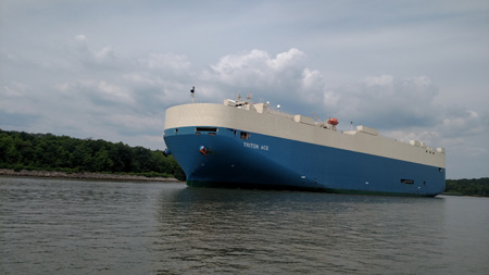
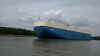
The high point of the transit is that just before we arrive at Welch
Point we see a large car carrier approaching from Chesapeake City.
Janice, at the helm, prudently advices we circle just outside the channel
to allow it plenty of room to pass. Good
advice; it’s huge, filling the narrowing channel.
Not often a ship that big passes so close to you.
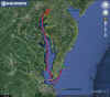
 |
Click image to enlarge |
 |
Showers, an excellent dinner at the Aqua Sol Restaurant and
navigation planning for our long passage down the Delaware Bay and along the
coast close out this long day. Hanno
develops a navigation plan to take maximum advantage of the ebb current in the
Delaware River and Bay that should get us to the mouth of the Bay by tomorrow
evening. Janice develops a navigation plan that will take us south along the
DELMARVA coast that minimizes the impact of the forecast S to SW winds. By the
time we turn in all agree it has been a good day on the water.
Day 3 - Summit North Marina to offshore via Delaware River
and Bay:
Jeff, shipper for the day, has us up, fed, pre-operations checks completed,
boat secured, water topped off and ready to go by 0745.
Before departing our slip we check to make sure the CONRAIL Railroad
Bridge is open and traffic is clear. We
have the canal to ourselves and make our potentially dangerous exit from the
C&D Canal (swift currents, shoal at exit) without incident. We motor sail
into a strong flood current and light southerly breezes.
The current will soon change so we will be able to take full advantage of
the ebb as we head toward the ocean.
As we pass Reedy Island, we identify a “bail-out”
landfall one would make in case of a sudden gale or problems with the boat; this
is a very narrow entrance through the Reedy Island Dyke. Once the current turns,
we find ourselves moving at 7+ knots for several hours. Tracking our progress by using fixes on lighthouses and other
navigation aids is becoming second nature to all. As we near the end of the Delaware Bay the
current begins to turn and the wind builds from the south.
All have seen the impact of wind against and with current and this is
clearly demonstrated as we pass Cape Henlopen carefully monitoring the passage
of the ferries moving between the two Capes. We attempt to sail without the
motor into light head winds but find our progress painfully slow so we furl the
genoa and motor sail, tacking along our rhumbline. The forecast calls for winds of 5- 10 knots from the SW and
the potential for showers and thunderstorms.
It’s prudent to put in a reef in the main even with these light
conditions so before dark we are moving under a reefed main.
Jeff and Ramon have the watch and see lightning in the distance.
As it gets closer we check the radar on a cell phone app and see a line
of thunderstorms approaching. Time for a second reef.
Within 10 minutes of getting the second reef in we are hit by rain and
strong winds over 30 knots. Reefing
before you need it is always good practice.
The squall soon passes and the night is spent motor sailing south
tracking our progress using electronic fixes from the GPS and visual fixes from
lights along the coast. The captain
reviews the “Standing Orders” with the crew and provides “Night Orders”
in the log to ensure that all know when to call on me if the wind shifts or
increases by certain values, a ship comes within a certain radius, etc.
Day 4 - Offshore Chesapeake Bay Entrance to Cape Charles
Harbor:
The night passes uneventfully and by morning we are off Assateague Light and
entrance to Chincoteague Inlet. The wind has built to 10 -15 knots and shifted to SW so we
decide to short tack along our rhumbline course in two to three hour legs to
give the engine a rest and stay close to the coast to minimize the impact of
building waves from the SW winds. By
late afternoon we are near Hog Island and the winds have dropped.
At times it has been a wild, bouncy ride but we still have a long way to
go to our stopover at Cape Charles so we motor sail along the coast but with an
watchful eye for shallow water. Our
navigation plan has us passing into the Chesapeake Bay under the North Channel
Bridge but a strong ebb current and narrow approach channel on a moonless night
cause us to alter our plans and enter thru the Chesapeake Channel.
Having alternatives is an important part of passage making.
This requires not only having thought through what alternative are
available but to have the charts and navigation information available to use
them if needed. We enter the
Chesapeake Bay at 0130 and head north to the Old Plantation Light at the
entrance to Cape Charles. By 0430 we are tied up at the Cape Charles Town Docks
and ready for bed. It has been a
long passage but all have done well. For
most of the crew this was their first time sailing at night and in the ocean.
It has been a good “baptism under fire.”
Day 5 - Cape Charles Harbor:
Before dropping off to a well-earned rest, we decide to spend the day in port
cleaning up, repairing some issues with the genoa furling line, studying and
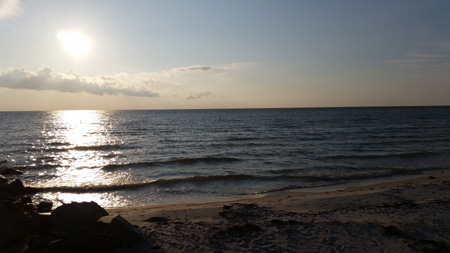
catching up on sleep. Cape Charles
is an interesting little town that is well worth exploring.
By early evening we are ready for a good meal, a walk to the beach and an
early bedtime in anticipation of our trip up the Bay.
Janice has laid out a course that will take us up to Annapolis initially
working against northerly winds that should veer to the E and SE by afternoon -
what no head winds for part of this leg! All
have no problem falling asleep.
 |
 |
Day 6/7 – Cape Charles Harbor to Annapolis and Rock Hall
The day dawns clear and a little cooler with northerly winds.
We are ready to depart for the fuel dock by 0930.
By the time we depart the Cape Charles channel we have NE winds 10-15
with gusts to 18-20 knots so a double reefed main and full genoa get us on our
way. We get a taste of the ship
traffic we will encounter later in the day as we monitor the progress of several
passing ships, coordinate passage with another and settle in for beat to the
north. By late morning it becomes
apparent that we are making slow progress along our course so in dying winds we
motor sail north toward Smith Point. By
the time we reach Smith Point at the entrance to the Potomac River we are moving
in a flat calm. At this key
waypoint we are greeted by the largest pod of dolphins we have yet seen on the
trip. As night falls we again put
in a reef in the main against a sudden change in wind direction and speed.
The wind does begin to veer to the SE but initially remains light.
We now start to see a steady increase in ship traffic.
AIS does its job, providing early warning of the approaching traffic that
will become 10 ships passing us between 2100 and 0400 hrs.
Several of these ships we coordinate passage with over VHF channel 13.
Shortly after the 0400 hour watch, we conduct a nighttime MOB drill.
On this moonless night all see how difficult it is to recover an MOB in
the dark. The ones most impacted
are the off watch crewmembers who were sound asleep and were called on deck for
the drill. The importance of
staying connected to the boat is understood by all.
The wind has built so we raise sail and rig a boom preventer.
It’s so nice to have our hard working engine turned off.
 |
 |
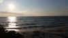
With the rising sun the wind dies away.
Of note is a line of cumulus clouds that have formed just over the middle
of the Bay. The Captain has seen
this along the Gulf Stream but never in the Bay.
The warmer Bay water contrasted with the cooler air over the land makes
for an interesting sight as the crew slowly comes alive and makes their way to
the deck. The forecast is for
continued light winds so the students opt for continuing to sail past Annapolis
and on to Lankford Bay, our homeport. Jeff, “skipper of the day” gets us
past the Key Bridge and up around Love Point where the crew determines it’s
time to turn off the motor and sail – into southerly head winds but a
beautiful clear day. As we
sail down the Chester River we hear the USCG reporting that water spouts have
been spotted by the Key Bridge; very strange weather to say the least.
It’s a great sail but slow progress, giving us a chance to practice all
points of sail. By 1500 it’s time
to “fold our wings” for the last time and return to the marina.
Three docking maneuvers area carried out - the pumpout dock, fuel dock
and slip - without a hitch by this well coordinated crew.
As we leave the fuel dock we are greeted with cheers by an ASA 101 class.
It’s good to be home. Our ship has taken good care of us so before
heading to well-earned showers and dinner we give her deck a good wash down,
clean the inside and store equipment. It’s
been a good trip. Now all that is
left is the ……“Test.”
 |
 |
Day 8, Lankford Bay Marina and the “Test”
On our final day together we have breakfast at Pasta Plus, complete boat
clean up and packing and head to the office for a chance to see just how much we
have learned over the last eight days. All
take and easily pass the ASA 106 test. I
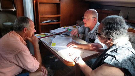
spend time with each student congratulating them on their accomplishments and
discussing their strengths and areas for further development.
Each has done well; we have been a good crew.
All look forward to the opportunity to apply newly developed skills in
their own sailing and look forward to sailing together again.
Well done, fellow mariners. I salute you – with thanks and
appreciation. Fair Winds to you,
always.
Captain Steve Runals
On board S/V NAVIGATOR
July 20, 2015
Rock Hall, Maryland

|